
Faire un don
Équipez-vous pour votre prochaine aventure :
En tant que Partenaire Amazon, ce site perçoit une commission sur les achats éligibles sans surcoût pour vous.
Carte topographique Tarrytown
Cliquez sur la carte pour afficher l’altitude.
Faire un don
Équipez-vous pour votre prochaine aventure :
En tant que Partenaire Amazon, ce site perçoit une commission sur les achats éligibles sans surcoût pour vous.
À propos de cette carte
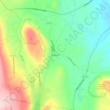
Nom : Carte topographique Tarrytown, altitude, relief.
Altitude moyenne : 222 m
Altitude minimum : 107 m
Altitude maximum : 402 m
Faire un don
Équipez-vous pour votre prochaine aventure :
En tant que Partenaire Amazon, ce site perçoit une commission sur les achats éligibles sans surcoût pour vous.
Autres cartes topographiques
Cliquez sur une carte pour visualiser sa topographie, son altitude et son relief.
John Boyd Thacher State Park
United States > New York > Albany County > Town of New Scotland
The escarpment features rocks of the Upper Silurian and Upper and Middle Ordovician ages resting below the Devonian rocks. At the base of the escarpment, the Schenectady beds are visible. The Rondout "waterlime" or dolomite overlies the Schenectady beds and is most pronounced below Minelot Falls. The…
Altitude moyenne : 262 m