Géolocaliser

Carte topographique Wymott

Cliquez sur la carte pour afficher l’altitude.

À propos de cette carte

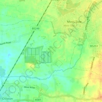
Nom : Carte topographique Wymott, altitude, relief.

Lieu : Wymott, Ulnes Walton, Chorley, Lancashire, England, PR26 8NH, United Kingdom (53.66088 -2.76627 53.70088 -2.72627)

Altitude moyenne : 17 m

Altitude minimum : 5 m

Altitude maximum : 31 m

Autres cartes topographiques

Cliquez sur une carte pour visualiser sa topographie, son altitude et son relief.

Bretherton

United Kingdom > England > Lancashire > Chorley > Bretherton

Altitude moyenne : 10 m

River Darwen

United Kingdom > England > Lancashire > Chorley

Altitude moyenne : 123 m

Adlington

United Kingdom > England > Lancashire > Chorley > Adlington

Altitude moyenne : 95 m

Withnell

United Kingdom > England > Lancashire > Chorley > Abbey Village

Altitude moyenne : 204 m

Moss Wood

United Kingdom > England > Lancashire > Chorley

Altitude moyenne : 8 m

Coppull

United Kingdom > England > Lancashire > Chorley

The settlement has an Anglo Saxon name describing its topography derived from the Old English copp a hill top and hyll a hill. The township was variously recorded as Cophull and Cophulle in 1277, Copphull in 1351, Copthull in 1374 and Coppull from 1444.

Altitude moyenne : 80 m

Charnock Richard

United Kingdom > England > Lancashire > Chorley

Altitude moyenne : 70 m

Whittle-le-Woods

United Kingdom > England > Lancashire > Chorley

Altitude moyenne : 88 m

Clayton-le-Woods

United Kingdom > England > Lancashire > Chorley

Altitude moyenne : 72 m

Euxton

United Kingdom > England > Lancashire > Chorley > Euxton

Altitude moyenne : 50 m

Brindle

United Kingdom > England > Lancashire > Chorley > Brindle

Altitude moyenne : 114 m

Heskin

United Kingdom > England > Lancashire > Chorley

Altitude moyenne : 56 m

Rivington

United Kingdom > England > Lancashire > Chorley > Rivington

Altitude moyenne : 244 m

Heapey

United Kingdom > England > Lancashire > Chorley > Wheelton

Altitude moyenne : 127 m

Croston

United Kingdom > England > Lancashire > Chorley

Altitude moyenne : 8 m

Bretherton

United Kingdom > England > Lancashire > Chorley

Altitude moyenne : 10 m

Wheelton

United Kingdom > England > Lancashire > Chorley

Altitude moyenne : 183 m

Coppull

United Kingdom > England > Lancashire > Chorley

The settlement has an Anglo Saxon name describing its topography derived from the Old English copp a hill top and hyll a hill. The township was variously recorded as Cophull and Cophulle in 1277, Copphull in 1351, Copthull in 1374 and Coppull from 1444.

Altitude moyenne : 82 m

Équipez-vous pour votre prochaine aventure :

🎒Poche à Eau - Réservoir d'eau avec tuyau pour s'hydrater sans s'arrêter.
📎Pince Multifonction - Légèreté et utilité maximale pour le petit bricolage.
⛸️Crampons de Chaussures - Sécurité antidérapante sur les sentiers verglacés.
🧭Boussoles robustes - Navigation résistante conditions extrêmes
🍎Plats Lyophilisés - Repas légers et nutritifs à préparer simplement avec de l'eau.

En tant que Partenaire Amazon, ce site perçoit une commission sur les achats éligibles sans surcoût pour vous.