
Carte topographique Lewdown
Cliquez sur la carte pour afficher l’altitude.
À propos de cette carte
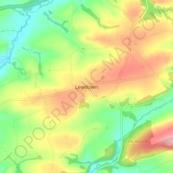
Nom : Carte topographique Lewdown, altitude, relief.
Lieu : Lewdown, West Devon, Devon, England, EX20 4DS, United Kingdom (50.63852 -4.21712 50.67852 -4.17712)
Altitude moyenne : 148 m
Altitude minimum : 73 m
Altitude maximum : 241 m
Autres cartes topographiques
Cliquez sur une carte pour visualiser sa topographie, son altitude et son relief.
Princetown
United Kingdom > England > Devon > West Devon
Princetown, like the rest of Dartmoor, experiences colder and wetter weather than most of Devon, especially because of its high altitude. Snow is uncommon but is usually heavy when it does fall. According to the Köppen climate classification the climate would be classified as Cfb bordering on Cfc.
Altitude moyenne : 415 m
Broadwoodkelly
United Kingdom > England > Devon > West Devon > Broadwoodkelly
Altitude moyenne : 129 m
Burrator Reservoir
United Kingdom > England > Devon > West Devon > Meavy > Sheepstor
Altitude moyenne : 255 m
Wistman's Wood (Nature Reserve)
United Kingdom > England > Devon > West Devon
Wistman's Wood is one of Britain's last remaining ancient temperate rainforests and one of three remote high-altitude oakwoods on Dartmoor in Devon, England. The first written document to mention Wistman's Wood dates to the 17th century, while more recent tree-ring studies show that individual trees could be…
Altitude moyenne : 433 m