
Faire un don
Équipez-vous pour votre prochaine aventure :
En tant que Partenaire Amazon, ce site perçoit une commission sur les achats éligibles sans surcoût pour vous.
Carte topographique Ashton-under-Lyne
Cliquez sur la carte pour afficher l’altitude.
Faire un don
Équipez-vous pour votre prochaine aventure :
En tant que Partenaire Amazon, ce site perçoit une commission sur les achats éligibles sans surcoût pour vous.
Ashton-under-Lyne
At 53°29′38″N 2°6′11″W / 53.49389°N 2.10306°W / 53.49389; -2.10306 (53.4941°, −2.1032°), and 160 miles (257 km) north-northwest of London, Ashton-under-Lyne stands on the north bank of the River Tame, about 35 feet (11 m) above the river. Described in Samuel Lewis's A Topographical Dictionary of England (1848) as situated "on a gentle declivity", Ashton-under-Lyne lies on undulating ground by the Pennines, reaching a maximum elevation of about 1,000 feet (305 m) above sea level. Generally the bedrock of the west of the town consists of coal measures, which were exploited by the coal mining industry, while the east is mainly millstone grit. Overlying the bedrock are deposits of glacial sand and gravel, clay, and some alluvial deposits. Ashton Moss, a peat bog, lies to the west of the town and was originally much larger.
Faire un don
Équipez-vous pour votre prochaine aventure :
En tant que Partenaire Amazon, ce site perçoit une commission sur les achats éligibles sans surcoût pour vous.
À propos de cette carte
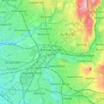
Nom : Carte topographique Ashton-under-Lyne, altitude, relief.
Altitude moyenne : 129 m
Altitude minimum : 63 m
Altitude maximum : 306 m
Faire un don
Équipez-vous pour votre prochaine aventure :
En tant que Partenaire Amazon, ce site perçoit une commission sur les achats éligibles sans surcoût pour vous.
Autres cartes topographiques
Cliquez sur une carte pour visualiser sa topographie, son altitude et son relief.
Faire un don
Équipez-vous pour votre prochaine aventure :
En tant que Partenaire Amazon, ce site perçoit une commission sur les achats éligibles sans surcoût pour vous.