
Carte topographique Daat Island
Carte interactive
Cliquez sur la carte pour afficher l’altitude.
À propos de cette carte
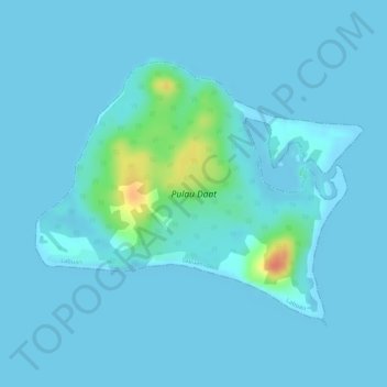
Nom : Carte topographique Daat Island, altitude, relief.
Lieu : Daat Island, Victoria, Labuan, Malaysia (5.26345 115.30630 5.28185 115.32933)
Altitude moyenne : 5 m
Altitude minimum : -1 m
Altitude maximum : 51 m
Autres cartes topographiques
Cliquez sur une carte pour visualiser sa topographie, son altitude et son relief.
Taman Awam Pantai Tanjung Purun
Malaysia > Labuan > Labuan > Victoria
Taman Awam Pantai Tanjung Purun, Victoria, Labuan, Malaysia
Altitude moyenne : 4 m