Géolocaliser

Carte topographique Lousada

Cliquez sur la carte pour afficher l’altitude.

À propos de cette carte
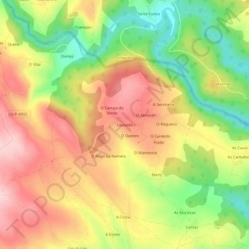
Nom : Carte topographique Lousada, altitude, relief.

Lieu : Lousada, Recelle, Portomarín, Lugo, Galicia, 27187, España (42.83292 -7.67435 42.87292 -7.63435)

Altitude moyenne : 474 m

Altitude minimum : 350 m

Altitude maximum : 584 m

Autres cartes topographiques

Cliquez sur une carte pour visualiser sa topographie, son altitude et son relief.

Vilaxuste

España > Galicia > Lugo > Portomarín

Altitude moyenne : 511 m

Soengas

España > Galicia > Lugo > Portomarín

Altitude moyenne : 615 m

Castromaior

España > Galicia > Lugo > Portomarín

Altitude moyenne : 596 m

Gonzar

España > Galicia > Lugo > Portomarín

Altitude moyenne : 551 m

Castromaior

España > Galicia > Lugo > Portomarín

Altitude moyenne : 596 m

Équipez-vous pour votre prochaine aventure :

☀️Crème Solaire Sport - Haute protection qui résiste à la transpiration.
👣Semelles de Confort - Amorti supplémentaire pour vos longues explorations topographiques.
🍴Couverts de Voyage - Set de couverts compacts et durables en titane ou inox.
🔥Réchaud de Camping - Matériel de cuisson compact et rapide pour vos repas en bivouac.
🌂Parapluie de Marche - Alternative à la veste pour rester au sec sans transpirer.

En tant que Partenaire Amazon, ce site perçoit une commission sur les achats éligibles sans surcoût pour vous.