
Carte topographique Odell
Carte interactive
Cliquez sur la carte pour afficher l’altitude.
À propos de cette carte
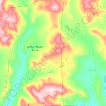
Nom : Carte topographique Odell, altitude, relief.
Lieu : Odell, Coös County, New Hampshire, United States (44.65996 -71.44437 44.79573 -71.32428)
Altitude moyenne : 673 m
Altitude minimum : 368 m
Altitude maximum : 1 114 m
A substantial portion of the state-owned Nash Stream Forest lies within the township. There are three mountains, each having elevations above 3,000 feet (910 m): Muise Mountain, Whitcomb Mountain and Long Mountain, whose two summits are the two highest points in Odell, at 3,661 feet (1,116 m) above sea level each. There are only a few rough roads and no highways here.