
Carte topographique West End
Cliquez sur la carte pour afficher l’altitude.
À propos de cette carte
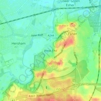
Nom : Carte topographique West End, altitude, relief.
Lieu : West End, Elmbridge, Surrey, England, KT10 8LY, United Kingdom (51.34275 -0.39929 51.38275 -0.35929)
Altitude moyenne : 24 m
Altitude minimum : 8 m
Altitude maximum : 54 m
Autres cartes topographiques
Cliquez sur une carte pour visualiser sa topographie, son altitude et son relief.
Esher
United Kingdom > England > Surrey > Elmbridge
Esher is an outlying suburb of London, close to the London–Surrey border; with Esher Commons at its southern end, the town marks one limit of the Greater London Built-Up Area. Esher has a linear commercial high street and is otherwise suburban in density, with varying elevations, few high rise buildings and…
Altitude moyenne : 21 m
Cobham
United Kingdom > England > Surrey > Elmbridge
The River Mole runs through Cobham, with a visitor area and well-surfaced path by the mill in the High Street, dividing the low-rise urban village/town centre from the remaining agricultural parts of Cobham in the west and south. This can flood small, old parts of the village centre in extreme rainfall.…
Altitude moyenne : 28 m