
Faire un don
Équipez-vous pour votre prochaine aventure :
En tant que Partenaire Amazon, ce site perçoit une commission sur les achats éligibles sans surcoût pour vous.
Carte topographique Cheaha Mountain
Cliquez sur la carte pour afficher l’altitude.
Faire un don
Équipez-vous pour votre prochaine aventure :
En tant que Partenaire Amazon, ce site perçoit une commission sur les achats éligibles sans surcoût pour vous.
Cheaha Mountain
Cheaha Mountain is part of the Talladega Mountains, a small section of the Ridge and Valley Mountains, unlike other elevations of the Appalachians in north Alabama, which are part of the Cumberland Plateau. The mountain is the highest point in the eastern portion of the Sun Belt (east of the Mississippi River, south of Interstate 20, and north of the Gulf of Mexico). The summit of the mountain gives an impression of being at a much higher elevation than it actually is, in part because of the relatively low elevation of the adjacent area to the west. For example, the summit of Cheaha Mountain (elevation 2,413 feet or 735 meters) measures roughly 1,725.72 feet (526 meters) above the city of Oxford (elevation 686 feet or 209 meters) near the base of the mountain. Geologically it is composed of weakly metamorphosed sandstones and conglomerates of the Cheaha quartzite, of Silurian / Devonian age, and stands high topographically due to the erosional resistance of these rocks. The soil, only moderately deep, is a brown stony silt loam of the Cheaha series; it is well drained and very strongly acidic.
Faire un don
Équipez-vous pour votre prochaine aventure :
En tant que Partenaire Amazon, ce site perçoit une commission sur les achats éligibles sans surcoût pour vous.
À propos de cette carte
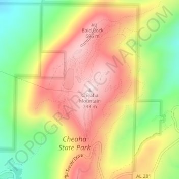
Nom : Carte topographique Cheaha Mountain, altitude, relief.
Lieu : Cheaha Mountain, Cleburne County, Alabama, United States (33.48557 -85.80883 33.48567 -85.80873)
Altitude moyenne : 543 m
Altitude minimum : 332 m
Altitude maximum : 733 m
Faire un don
Équipez-vous pour votre prochaine aventure :
En tant que Partenaire Amazon, ce site perçoit une commission sur les achats éligibles sans surcoût pour vous.
Autres cartes topographiques
Cliquez sur une carte pour visualiser sa topographie, son altitude et son relief.