
Carte topographique Gilroy
Cliquez sur la carte pour afficher l’altitude.
Gilroy
Due to the moderating influence of the Pacific Ocean, Gilroy experiences a warm Mediterranean climate (Köppen Csb, bordering on Csa). Temperatures range from an average midsummer maximum of 90.1 °F (32.3 °C) to an average midwinter low of 33.6 °F (0.9 °C). Average annual precipitation is 18.9 inches (480 mm), and the summer months are typically dry. Snowfall is rare; occurring approximately once every 20 years, it is light and short-lived. Summer months are characterized by coastal fog which arrives from the ocean around 10 p.m. and dissipates the next morning by 10 a.m. During summer afternoons, the maritime influence lowers and, as a result, Gilroy is much more prone to heat waves than nearby geographical areas to its north and west. Winter months have many sunny and partly cloudy days, with frequent breaks between rainstorms. The local terrain is not conducive to tornadoes, severe windstorms, or thunderstorms. The local climate supports chaparral and grassland biomes, with stands of live oak at higher elevations.
À propos de cette carte
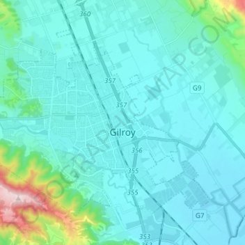
Nom : Carte topographique Gilroy, altitude, relief.
Lieu : Gilroy, Santa Clara County, California, United States (36.97235 -121.64336 37.04821 -121.51880)
Altitude moyenne : 107 m
Altitude minimum : 41 m
Altitude maximum : 597 m
Autres cartes topographiques
Cliquez sur une carte pour visualiser sa topographie, son altitude et son relief.
Santa Cruz Mountains
United States > California > Santa Clara County
The Santa Cruz Mountains are a region of great biological diversity, encompassing cool, moist coastal ecosystems as well as warm, dry chaparral. Much of the area in the Santa Cruz mountains is considered temperate rainforest. In valleys and moist ocean-facing slopes some of the southernmost coast redwoods…
Altitude moyenne : 230 m
Coyote
United States > California > Santa Clara County
Due to the moderating influence of the Pacific Ocean, Coyote enjoys a mild, Mediterranean climate. Temperatures range from an average midsummer maximum of 32.3°C (90.2°F) to an average midwinter low of 0.9 °C (33.6 °F). Average annual precipitation is 480 mm (18.9 in), and the summer months are typically…
Altitude moyenne : 131 m
Lexington Hills
United States > California > Santa Clara County > Redwood Estates
Altitude moyenne : 424 m
Vasona Lake County Park
United States > California > Santa Clara County > Los Gatos > Shannon
Altitude moyenne : 109 m
Mount Umunhum
United States > California > Santa Clara County
The mountain is also the site of the Bay Area NEXRAD weather radar. The high elevation is necessary for line of sight in the region's varied terrain, but it also limits the ability to detect storms with bases lower in the atmosphere.
Altitude moyenne : 770 m
Los Altos Hills
United States > California > Santa Clara County > Los Altos Hills > Los Altos Hills
Altitude moyenne : 94 m
Morgan Hill
United States > California > Santa Clara County > Morgan Hill
Morgan Hill is approximately 39 km (24 mi) south of downtown San Jose, 21 km (13 mi) north of Gilroy, and 24 km (15 mi) inland from the Pacific coast. Lying in a roughly 6 km-wide (4-mi-wide) southern extension of the Santa Clara Valley, it is bounded by the Santa Cruz Mountains to the west and the Diablo…
Altitude moyenne : 145 m
Santa Cruz Mountains
United States > California > Santa Clara County
The Santa Cruz Mountains are a region of great biological diversity, encompassing cool, moist coastal ecosystems as well as warm, dry chaparral. Much of the area in the Santa Cruz mountains is temperate rainforest. In valleys and moist ocean-facing slopes some of the southernmost coast redwoods grow, along…
Altitude moyenne : 230 m
Pacheco Pass
United States > California > Santa Clara County
Pacheco Pass, elevation 1,368 ft (417 m), is a low mountain pass located in the Diablo Range in southeastern Santa Clara County, California. It is the main route through the hills separating the Santa Clara Valley and the Central Valley.
Altitude moyenne : 425 m
Creekside Village
United States > California > Santa Clara County > Los Gatos
Altitude moyenne : 166 m