
Faire un don
Équipez-vous pour votre prochaine aventure :
En tant que Partenaire Amazon, ce site perçoit une commission sur les achats éligibles sans surcoût pour vous.
Carte topographique Emmaus
Cliquez sur la carte pour afficher l’altitude.
Faire un don
Équipez-vous pour votre prochaine aventure :
En tant que Partenaire Amazon, ce site perçoit une commission sur les achats éligibles sans surcoût pour vous.
Emmaus
According to the U.S. Census Bureau, the borough has a total area of 2.9 square miles (7.5 km2), all land, though part of Little Lehigh Creek, a tributary of the Lehigh River, flows just outside the Emmaus border with Salisbury Township. Emmaus borders South Mountain, a large Appalachian mountain range. The town's elevation is 436 feet above sea level. Emmaus is located at approximately 40°32′13″N 75°29′45″W / 40.53694°N 75.49583°W / 40.53694; -75.49583. It has a hot-summer humid continental climate (Dfa) and is in hardiness zone 6b. Average monthly temperatures in the downtown vicinity range from 28.9 °F in January to 73.5 °F in July.
Faire un don
Équipez-vous pour votre prochaine aventure :
En tant que Partenaire Amazon, ce site perçoit une commission sur les achats éligibles sans surcoût pour vous.
À propos de cette carte
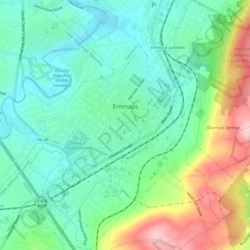
Nom : Carte topographique Emmaus, altitude, relief.
Lieu : Emmaus, Lehigh County, Pennsylvania, 18049, United States (40.51674 -75.52038 40.55645 -75.47900)
Altitude moyenne : 154 m
Altitude minimum : 89 m
Altitude maximum : 296 m
Faire un don
Équipez-vous pour votre prochaine aventure :
En tant que Partenaire Amazon, ce site perçoit une commission sur les achats éligibles sans surcoût pour vous.