
Carte topographique Jersey City
Carte interactive
Cliquez sur la carte pour afficher l’altitude.
À propos de cette carte
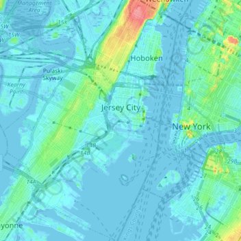
Nom : Carte topographique Jersey City, altitude, relief.
Lieu : Jersey City, Hudson County, New Jersey, United States (40.66162 -74.11669 40.76894 -74.02064)
Altitude moyenne : 9 m
Altitude minimum : -8 m
Altitude maximum : 80 m
Jersey City (and most of Hudson County) is located on the peninsula known as Bergen Neck, with a waterfront on the east at the Hudson River and New York Bay and on the west at the Hackensack River and Newark Bay. Its north–south axis corresponds with the ridge of Bergen Hill, the emergence of the Hudson Palisades. The city is the site of some of the earliest European settlements in North America, which grew into each other rather than expanding from a central point. This growth and the topography greatly influenced the development of the sections of the city and its various neighborhoods.
Autres cartes topographiques
Cliquez sur une carte pour visualiser sa topographie, son altitude et son relief.
Secaucus
United States > New Jersey > Hudson County
Secaucus, Hudson County, New Jersey, United States
Altitude moyenne : 13 m
Hoboken
United States > New Jersey > Hudson County
Hoboken, Hudson County, New Jersey, United States
Altitude moyenne : 14 m
Jersey City
United States > New Jersey > Hudson County > Jersey City
Jersey City, Hudson County, New Jersey, 07302, United States
Altitude moyenne : 21 m