
Faire un don
Équipez-vous pour votre prochaine aventure :
En tant que Partenaire Amazon, ce site perçoit une commission sur les achats éligibles sans surcoût pour vous.
Carte topographique Yiliang
Cliquez sur la carte pour afficher l’altitude.
Faire un don
Équipez-vous pour votre prochaine aventure :
En tant que Partenaire Amazon, ce site perçoit une commission sur les achats éligibles sans surcoût pour vous.
À propos de cette carte
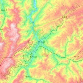
Nom : Carte topographique Yiliang, altitude, relief.
Lieu : Yiliang, Zhaotong City, Yunnan, China (27.46730 103.89380 27.78730 104.21380)
Altitude moyenne : 1 602 m
Altitude minimum : 721 m
Altitude maximum : 2 666 m
Faire un don
Équipez-vous pour votre prochaine aventure :
En tant que Partenaire Amazon, ce site perçoit une commission sur les achats éligibles sans surcoût pour vous.
Autres cartes topographiques
Cliquez sur une carte pour visualiser sa topographie, son altitude et son relief.
Faire un don
Équipez-vous pour votre prochaine aventure :
En tant que Partenaire Amazon, ce site perçoit une commission sur les achats éligibles sans surcoût pour vous.
Faire un don
Équipez-vous pour votre prochaine aventure :
En tant que Partenaire Amazon, ce site perçoit une commission sur les achats éligibles sans surcoût pour vous.
Kunming
Kunming (/kʊnˈmɪŋ/;[3] Chinese: 昆明; pinyin: Kūnmíng), also known as Yunnan-Fu, is the capital and largest city of Yunnan province, China.[4] It is the political, economic, communications and cultural centre of the province as well as the seat of the provincial government. The headquarters of many of…
Altitude moyenne : 1 463 m
Faire un don
Équipez-vous pour votre prochaine aventure :
En tant que Partenaire Amazon, ce site perçoit une commission sur les achats éligibles sans surcoût pour vous.
Kunming
Kunming is at an altitude of 1,900 metres (6,234 feet) above sea level and a latitude just north of the Tropic of Cancer, and is situated in the middle of the Yunnan–Guizhou Plateau. Kunming is the fourth most populous city in Western China, after Chongqing, Chengdu, and Xi'an, and the third most populous…
Altitude moyenne : 1 996 m
Shilin Stone Forest Landscape District
China > Yunnan > Shilin Yi Autonomous County > Kunming
The strata are part of a gentle (2-6 degree) westward dipping monocline. Conjugate shear joints (NE-SW and NE-SE) are well developed and these fractures provided the main passageways for surface and underground water in the pre-karst development stage. The distribution, density and orientation of the fractures…
Altitude moyenne : 1 767 m
Faire un don
Équipez-vous pour votre prochaine aventure :
En tant que Partenaire Amazon, ce site perçoit une commission sur les achats éligibles sans surcoût pour vous.
Dali City
Its low latitude tempered by its high elevation, Dali has a mild subtropical highland climate (Köppen Cwb) with short, mild, dry winters and warm, rainy summers. Frost may occur in winter but the days still generally warm up to 16 °C (61 °F) or more. During summer, a majority of the days features some…
Altitude moyenne : 2 172 m
Yuanyang County
It covers an area of 2,200 km2 (850 sq mi) and has a population of approximately 365,000 (2002), of which 88% belong to ethnic minorities and 95% is associated with agriculture. The majority of the inhabitants of the county are from the Hani ethnic group. The GDP of Yuanyang county in 2021 was 9,312 million…
Altitude moyenne : 1 358 m
Faire un don
Équipez-vous pour votre prochaine aventure :
En tant que Partenaire Amazon, ce site perçoit une commission sur les achats éligibles sans surcoût pour vous.
Tengchong City
Situated at the southwestern end of the (transversely faulted) Hengduan Mountains, Tengchong topographically assumes the form of a horseshoe with the opening facing the south. The easternmost sources of the Irrawaddy River issue from the high mountains at the summit of Mount Danaozi of Gaoligong Mountain,…
Altitude moyenne : 1 830 m
Faire un don
Équipez-vous pour votre prochaine aventure :
En tant que Partenaire Amazon, ce site perçoit une commission sur les achats éligibles sans surcoût pour vous.
Dêqên County
Being located at an altitude of 3,300 metres (10,800 ft), Deqin lies in the transition between a subtropical highland climate (Köppen Cwb) and humid continental climate (Köppen Dwb), which is remarkable for its latitude. Although mean maximum temperatures, as in Lhasa and Shigatse, stay above freezing…
Altitude moyenne : 3 590 m
Faire un don
Équipez-vous pour votre prochaine aventure :
En tant que Partenaire Amazon, ce site perçoit une commission sur les achats éligibles sans surcoût pour vous.
Kunming
Kunming is at an altitude of 1,900 metres (6,234 feet) above sea level and a latitude just north of the Tropic of Cancer, and is situated in the middle of the Yunnan–Guizhou Plateau. Kunming is the fourth most populous city in Western China, after Chongqing, Chengdu, and Xi'an, and the third most populous…
Altitude moyenne : 1 996 m
Shangri-La
Shangri-La has either a dry-winter, warm-summer humid continental climate (Köppen climate classification: Dwb) using the 0 °C (32 °F) isotherm, or a dry-winter subtropical highland climate (Köppen climate classification: Cwb) using the −3 °C (26.6 °F) isotherm, both of which are unusually cool by…
Altitude moyenne : 3 342 m
Faire un don
Équipez-vous pour votre prochaine aventure :
En tant que Partenaire Amazon, ce site perçoit une commission sur les achats éligibles sans surcoût pour vous.
Faire un don
Équipez-vous pour votre prochaine aventure :
En tant que Partenaire Amazon, ce site perçoit une commission sur les achats éligibles sans surcoût pour vous.
Shangri-La
Shangri-La has either a dry-winter, warm-summer humid continental climate (Köppen climate classification: Dwb) using the 0 °C (32 °F) isotherm, or a dry-winter subtropical highland climate (Köppen climate classification: Cwb) using the −3 °C (26.6 °F) isotherm, both of which are unusually cool by…
Altitude moyenne : 3 342 m
Xishuangbanna
The prefecture has an area of 19,700 km2 (7,600 sq mi). Xishuangbanna is the home of the Dai people. The region sits at a lower altitude than most of Yunnan, and has a tropical savanna climate (Köppen climate classification Aw).
Altitude moyenne : 1 106 m
Shangri-La
Shangri-La has either a dry-winter, warm-summer humid continental climate (Köppen climate classification: Dwb) using the 0 °C (32 °F) isotherm, or a dry-winter subtropical highland climate (Köppen climate classification: Cwb) using the −3 °C (26.6 °F) isotherm, both of which are unusually cool by…
Altitude moyenne : 3 342 m
Faire un don
Équipez-vous pour votre prochaine aventure :
En tant que Partenaire Amazon, ce site perçoit une commission sur les achats éligibles sans surcoût pour vous.
Kunming
Kunming is at an altitude of 1,900 metres (6,234 feet) above sea level and a latitude just north of the Tropic of Cancer, and is situated in the middle of the Yunnan–Guizhou Plateau. Kunming is the fourth most populous city in Western China, after Chongqing, Chengdu, and Xi'an, and the third most populous…
Altitude moyenne : 1 996 m
Baihetan Dam
China > Yunnan > Qiaojia County > Zhaotong City > Dazhai
The Baihetan Dam (simplified Chinese: 白鹤滩大坝; traditional Chinese: 白鶴灘大壩; pinyin: Báihètān Dàbà) is a large hydroelectric dam on the Jinsha River, an upper stretch of the Yangtze River in Sichuan and Yunnan provinces, in southwest China. The dam is a 289-meter-tall double-curvature arch…
Altitude moyenne : 1 061 m
Faire un don
Équipez-vous pour votre prochaine aventure :
En tant que Partenaire Amazon, ce site perçoit une commission sur les achats éligibles sans surcoût pour vous.
Napahai Nature Reserve
China > Yunnan > Shangri-La > Jiantang > Chui Zongdala
Altitude moyenne : 3 410 m
Faire un don
Équipez-vous pour votre prochaine aventure :
En tant que Partenaire Amazon, ce site perçoit une commission sur les achats éligibles sans surcoût pour vous.
Kunming
Kunming is at an altitude of 1,900 metres (6,234 feet) above sea level and a latitude just north of the Tropic of Cancer, and is situated in the middle of the Yunnan–Guizhou Plateau. Kunming is the fourth most populous city in Western China, after Chongqing, Chengdu, and Xi'an, and the third most populous…
Altitude moyenne : 1 463 m
Xishuangbanna
The prefecture has an area of 19,700 km2 (7,600 sq mi). Xishuangbanna is the home of the Dai people. The region sits at a lower altitude than most of Yunnan, and has a humid subtropical climate (Köppen climate classification Cfa) that borders closely on a tropical savanna climate (Köppen climate…
Altitude moyenne : 1 103 m
Faire un don
Équipez-vous pour votre prochaine aventure :
En tant que Partenaire Amazon, ce site perçoit une commission sur les achats éligibles sans surcoût pour vous.
Kunming
Kunming is at an altitude of 1,900 metres (6,234 feet) above sea level and a latitude just north of the Tropic of Cancer, and is situated in the middle of the Yunnan–Guizhou Plateau. Kunming is the fourth most populous city in Western China, after Chongqing, Chengdu, and Xi'an, and the third most populous…
Altitude moyenne : 1 996 m
Zhaotong City
Influenced by the low latitude and moderate elevation, Zhaotong has a temperate subtropical highland climate (Köppen Cwb), with cool, dry winters, and warm, humid summers. Temperatures frequently drop below freezing at night in winter, though the days warm up to around 10 °C (50 °F). Conversely, in summer,…
Altitude moyenne : 1 899 m
Faire un don
Équipez-vous pour votre prochaine aventure :
En tant que Partenaire Amazon, ce site perçoit une commission sur les achats éligibles sans surcoût pour vous.
Pu'er City
Pu'er is located in southern/southwestern Yunnan, on the lower reaches of the Mekong (known in Chinese as the Lancang), with the bordering prefectures being Yuxi to the northeast, Honghe to the east, Xishuangbanna to the south, Lincang to the northwest, and Dali and Chuxiong. It also shares borders with…
Altitude moyenne : 1 479 m
Faire un don
Équipez-vous pour votre prochaine aventure :
En tant que Partenaire Amazon, ce site perçoit une commission sur les achats éligibles sans surcoût pour vous.
Faire un don
Équipez-vous pour votre prochaine aventure :
En tant que Partenaire Amazon, ce site perçoit une commission sur les achats éligibles sans surcoût pour vous.
Kunming
Kunming (/kʊnˈmɪŋ/; Chinese: 昆明; pinyin: Kūnmíng), also known as Yunnan-Fu, is the capital and largest city of Yunnan province, China. It is the political, economic, communications and cultural centre of the province as well as the seat of the provincial government. The city was of great significance…
Altitude moyenne : 1 996 m
Faire un don
Équipez-vous pour votre prochaine aventure :
En tant que Partenaire Amazon, ce site perçoit une commission sur les achats éligibles sans surcoût pour vous.
Lijiang City
Owing to its low latitude and high elevation, the city centre of Lijiang experiences a mild subtropical highland climate (Köppen Cwb). Winters are mild and very dry and sunny (>70% possible sunshine), although average lows in December and January are just below the freezing mark; January, the coolest month,…
Altitude moyenne : 2 735 m
Faire un don
Équipez-vous pour votre prochaine aventure :
En tant que Partenaire Amazon, ce site perçoit une commission sur les achats éligibles sans surcoût pour vous.
Faire un don
Équipez-vous pour votre prochaine aventure :
En tant que Partenaire Amazon, ce site perçoit une commission sur les achats éligibles sans surcoût pour vous.
Honghe Hani Rice Terraces
China > Yunnan > Yuanyang County > Zhulu
The terraces follow a distinct vertical structure that has allowed the landscape to persist for so long, incorporating forests, villages, terraces, and water supply. At the tops of the mountains (above 2000 meters in elevation), the forests are conserved, to act as a catchment for the rainfall and to…
Altitude moyenne : 1 585 m
Faire un don
Équipez-vous pour votre prochaine aventure :
En tant que Partenaire Amazon, ce site perçoit une commission sur les achats éligibles sans surcoût pour vous.
Faire un don
Équipez-vous pour votre prochaine aventure :
En tant que Partenaire Amazon, ce site perçoit une commission sur les achats éligibles sans surcoût pour vous.
Gongshan Derung and Nu Autonomous County
China > Yunnan > Gongshan Derung and Nu Autonomous County > Cikai
Altitude moyenne : 3 255 m
Faire un don
Équipez-vous pour votre prochaine aventure :
En tant que Partenaire Amazon, ce site perçoit une commission sur les achats éligibles sans surcoût pour vous.
Yuanyang County
It covers an area of 2,200 km2 (850 sq mi) and has a population of approximately 365,000 (2002), of which 88% belong to ethnic minorities and 95% is associated with agriculture. The majority of the inhabitants of the county are from the Hani ethnic group. The GDP of Yuanyang county in 2021 was 9,312 million…
Altitude moyenne : 1 358 m
Qidian Subdistrict
China > Yunnan > Chenggong District > Qidian Subdistrict
Altitude moyenne : 2 026 m
Faire un don
Équipez-vous pour votre prochaine aventure :
En tant que Partenaire Amazon, ce site perçoit une commission sur les achats éligibles sans surcoût pour vous.
Lijiang City
Owing to its low latitude and high elevation, the city centre of Lijiang experiences a mild subtropical highland climate (Köppen Cwb). Winters are mild and very dry and sunny (>70% possible sunshine), although average lows in December and January are just below the freezing mark; January, the coolest month,…
Altitude moyenne : 2 735 m
Faire un don
Équipez-vous pour votre prochaine aventure :
En tant que Partenaire Amazon, ce site perçoit une commission sur les achats éligibles sans surcoût pour vous.