
Faire un don
Équipez-vous pour votre prochaine aventure :
En tant que Partenaire Amazon, ce site perçoit une commission sur les achats éligibles sans surcoût pour vous.
Carte topographique East Poblacion
Cliquez sur la carte pour afficher l’altitude.
Faire un don
Équipez-vous pour votre prochaine aventure :
En tant que Partenaire Amazon, ce site perçoit une commission sur les achats éligibles sans surcoût pour vous.
À propos de cette carte
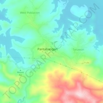
Nom : Carte topographique East Poblacion, altitude, relief.
Altitude moyenne : 287 m
Altitude minimum : 193 m
Altitude maximum : 507 m
Faire un don
Équipez-vous pour votre prochaine aventure :
En tant que Partenaire Amazon, ce site perçoit une commission sur les achats éligibles sans surcoût pour vous.
Autres cartes topographiques
Cliquez sur une carte pour visualiser sa topographie, son altitude et son relief.
Pantabangan Dam
Philippines > Nueva Ecija > Pantabangan > Fatima
The dam is a 107 m (351 ft) tall and 1,615 m (5,299 ft) long embankment-type with 12,000,000 cu yd (9,174,658 m3) of homogeneous earth-fill and an impervious core. The crest of the dam is 12 m (39 ft) wide while the widest part of its base is 535 m (1,755 ft). The dam's crest sits at an elevation of 232 m (761…
Altitude moyenne : 210 m
Faire un don
Équipez-vous pour votre prochaine aventure :
En tant que Partenaire Amazon, ce site perçoit une commission sur les achats éligibles sans surcoût pour vous.