
Faire un don
Équipez-vous pour votre prochaine aventure :
En tant que Partenaire Amazon, ce site perçoit une commission sur les achats éligibles sans surcoût pour vous.
Carte topographique Black Fell
Cliquez sur la carte pour afficher l’altitude.
Faire un don
Équipez-vous pour votre prochaine aventure :
En tant que Partenaire Amazon, ce site perçoit une commission sur les achats éligibles sans surcoût pour vous.
Black Fell
Black Fell is the high point in the hilly area bounded by Windermere, Langdale and Coniston. It occupies an area of around one mile by two, clad mainly in fell grass with many small outcrops of rock. Despite its modest altitude Alfred Wainwright accorded Black Fell a chapter in his Pictorial Guide to the Lakeland Fells, partly due to its excellence as a view point. It represents the perimeter of the Lakeland Fells proper in his opinion, the land to the south falling within his supplementary volume, The Outlying Fells of Lakeland. Later guidebook writers have also included Black Fell within their remit.
Faire un don
Équipez-vous pour votre prochaine aventure :
En tant que Partenaire Amazon, ce site perçoit une commission sur les achats éligibles sans surcoût pour vous.
À propos de cette carte
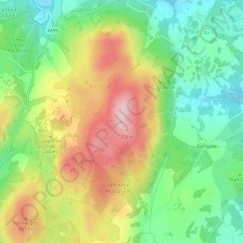
Nom : Carte topographique Black Fell, altitude, relief.
Altitude moyenne : 170 m
Altitude minimum : 60 m
Altitude maximum : 320 m
Faire un don
Équipez-vous pour votre prochaine aventure :
En tant que Partenaire Amazon, ce site perçoit une commission sur les achats éligibles sans surcoût pour vous.
Autres cartes topographiques
Cliquez sur une carte pour visualiser sa topographie, son altitude et son relief.
Wharton Tarn
United Kingdom > England > Westmorland and Furness > Hawkshead > Hawkshead Hill
Altitude moyenne : 173 m