
Faire un don
Équipez-vous pour votre prochaine aventure :
En tant que Partenaire Amazon, ce site perçoit une commission sur les achats éligibles sans surcoût pour vous.
Carte topographique Ago di Sciora
Cliquez sur la carte pour afficher l’altitude.
Faire un don
Équipez-vous pour votre prochaine aventure :
En tant que Partenaire Amazon, ce site perçoit une commission sur les achats éligibles sans surcoût pour vous.
À propos de cette carte
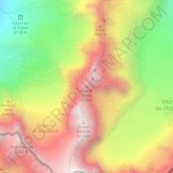
Nom : Carte topographique Ago di Sciora, altitude, relief.
Lieu : Ago di Sciora, Bregaglia, Maloja, Grisons, Switzerland (46.30160 9.62594 46.30170 9.62604)
Altitude moyenne : 2 637 m
Altitude minimum : 1 938 m
Altitude maximum : 3 254 m
Faire un don
Équipez-vous pour votre prochaine aventure :
En tant que Partenaire Amazon, ce site perçoit une commission sur les achats éligibles sans surcoût pour vous.
Autres cartes topographiques
Cliquez sur une carte pour visualiser sa topographie, son altitude et son relief.
Pontresina
Switzerland > Grisons > Maloja
Before 2017, the municipality was located in the Oberengadin sub-district of the Maloja district, after 2017 it was part of the Maloja Region. It sits in Val Bernina, which is the highest altitude valley that branches off the Upper Engadin Valley. The municipality includes the highest mountain of the canton,…
Altitude moyenne : 2 580 m
Faire un don
Équipez-vous pour votre prochaine aventure :
En tant que Partenaire Amazon, ce site perçoit une commission sur les achats éligibles sans surcoût pour vous.
Pontresina
Switzerland > Grisons > Maloja
Before 2017, the municipality was located in the Oberengadin sub-district of the Maloja district, after 2017 it was part of the Maloja Region. It sits in Val Bernina, which is the highest altitude valley that branches off the Upper Engadin Valley. The municipality includes the highest mountain of the canton,…
Altitude moyenne : 2 580 m
Sankt Moritz
Switzerland > Grisons > Maloja
St. Moritz (/ˌsæn məˈrɪts/ SAN mə-RITS, US also /ˌseɪnt -/ SAYNT -, UK also /sənt ˈmɒrɪts/ sənt MORR-its; German, in full: Sankt Moritz [zaŋkt moˈrɪts, ˈmoːrɪts] locally [saŋkt]; Romansh: San Murezzan [sam muˈʁetsən] ; Italian: San Maurizio; French: Saint-Moritz) is a high Alpine…
Altitude moyenne : 2 173 m
Faire un don
Équipez-vous pour votre prochaine aventure :
En tant que Partenaire Amazon, ce site perçoit une commission sur les achats éligibles sans surcoût pour vous.
Pontresina
Switzerland > Grisons > Maloja
Before 2017, the municipality was located in the Oberengadin sub-district of the Maloja district, after 2017 it was part of the Maloja Region. It sits in Val Bernina, which is the highest altitude valley that branches off the Upper Engadin Valley. The municipality includes the highest mountain of the canton,…
Altitude moyenne : 2 580 m
Sankt Moritz
Switzerland > Grisons > Maloja
St. Moritz (also German: Sankt Moritz, Romansh: San Murezzan (help·info), Italian: San Maurizio, French: Saint-Moritz) is a high Alpine resort town in the Engadine in Switzerland, at an elevation of about 1,800 metres (5,910 ft) above sea level. It is Upper Engadine's major town and a municipality in the…
Altitude moyenne : 2 173 m
Faire un don
Équipez-vous pour votre prochaine aventure :
En tant que Partenaire Amazon, ce site perçoit une commission sur les achats éligibles sans surcoût pour vous.
Sankt Moritz
Switzerland > Grisons > Maloja
St. Moritz (/ˌsæn məˈrɪts/ SAN mə-RITS, US also /ˌseɪnt -/ SAYNT -, UK also /sənt ˈmɒrɪts/ sənt MORR-its; German, in full: Sankt Moritz [zaŋkt moˈrɪts, ˈmoːrɪts] locally [saŋkt]; Romansh: San Murezzan [sam muˈʁetsən] ; Italian: San Maurizio; French: Saint-Moritz) is a high Alpine…
Altitude moyenne : 2 173 m
Lägh dal Lunghin
Switzerland > Grisons > Maloja
Lägh dal Lunghin (German: Lunghinsee) is a lake at an elevation of 2484 m, below the peak of Piz Lunghin, in the Graubünden, Switzerland. It is considered the source of the Inn River.
Altitude moyenne : 2 456 m
Faire un don
Équipez-vous pour votre prochaine aventure :
En tant que Partenaire Amazon, ce site perçoit une commission sur les achats éligibles sans surcoût pour vous.