
Faire un don
Équipez-vous pour votre prochaine aventure :
En tant que Partenaire Amazon, ce site perçoit une commission sur les achats éligibles sans surcoût pour vous.
Carte topographique Dorado
Cliquez sur la carte pour afficher l’altitude.
Faire un don
Équipez-vous pour votre prochaine aventure :
En tant que Partenaire Amazon, ce site perçoit une commission sur les achats éligibles sans surcoût pour vous.
Dorado
Dorado is located in Puerto Rico's Northern Karst region. Much of its geology consists of alluvial and coastal/estuarine sediments of Quaternary age and limestones of Tertiary age. The limestones are mostly in the south part of the municipality, in Espinosa, Maguayo and Rio Lajas barrios. These limestones exhibit mature karst topography of great beauty. It has been subjected to extensive quarrying, which have left unsightly scars in the landscape. Some local communities have gathered efforts to minimize quarrying and improve land management to protect the remaining karst topography and the fauna and flora that lives in it.
Faire un don
Équipez-vous pour votre prochaine aventure :
En tant que Partenaire Amazon, ce site perçoit une commission sur les achats éligibles sans surcoût pour vous.
À propos de cette carte
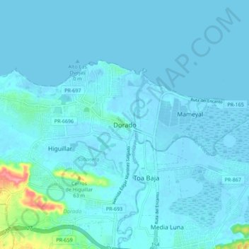
Nom : Carte topographique Dorado, altitude, relief.
Lieu : Dorado, Puerto Rico, 00646, United States (18.41938 -66.30153 18.49938 -66.22153)
Altitude moyenne : 7 m
Altitude minimum : -3 m
Altitude maximum : 92 m
Faire un don
Équipez-vous pour votre prochaine aventure :
En tant que Partenaire Amazon, ce site perçoit une commission sur les achats éligibles sans surcoût pour vous.