
Carte topographique Irvine
Carte interactive
Cliquez sur la carte pour afficher l’altitude.
À propos de cette carte
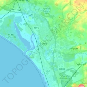
Nom : Carte topographique Irvine, altitude, relief.
Lieu : Irvine, North Ayrshire, Scotland, KA12 0AX, United Kingdom (55.57431 -4.70556 55.65431 -4.62556)
Altitude moyenne : 13 m
Altitude minimum : -2 m
Altitude maximum : 87 m
Autres cartes topographiques
Cliquez sur une carte pour visualiser sa topographie, son altitude et son relief.
Kilbirnie
United Kingdom > Scotland > North Ayrshire
Kilbirnie, North Ayrshire, Scotland, KA25 7BY, United Kingdom
Altitude moyenne : 121 m
Grangehill
United Kingdom > Scotland > North Ayrshire > Beith
Grangehill, Beith, North Ayrshire, Scotland, KA15 2JJ, United Kingdom
Altitude moyenne : 96 m
Ballochmartin
United Kingdom > Scotland > North Ayrshire > Millport > Ballochmartin
Ballochmartin, Millport, North Ayrshire, Scotland, KA28 0HQ, United Kingdom
Altitude moyenne : 22 m
Kilwinning
United Kingdom > Scotland > North Ayrshire
Kilwinning, North Ayrshire, Scotland, KA13 6AD, United Kingdom
Altitude moyenne : 36 m
Ardrossan
United Kingdom > Scotland > North Ayrshire
Ardrossan, North Ayrshire, Scotland, KA22 8BS, United Kingdom
Altitude moyenne : 21 m