
Faire un don
Équipez-vous pour votre prochaine aventure :
En tant que Partenaire Amazon, ce site perçoit une commission sur les achats éligibles sans surcoût pour vous.
Carte topographique Koura District
Cliquez sur la carte pour afficher l’altitude.
Faire un don
Équipez-vous pour votre prochaine aventure :
En tant que Partenaire Amazon, ce site perçoit une commission sur les achats éligibles sans surcoût pour vous.
À propos de cette carte
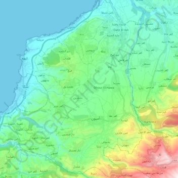
Nom : Carte topographique Koura District, altitude, relief.
Lieu : Koura District, North Governorate, 1306, Lebanon (34.24264 35.70400 34.41393 35.87491)
Altitude moyenne : 297 m
Altitude minimum : 0 m
Altitude maximum : 1 423 m
Faire un don
Équipez-vous pour votre prochaine aventure :
En tant que Partenaire Amazon, ce site perçoit une commission sur les achats éligibles sans surcoût pour vous.
Autres cartes topographiques
Cliquez sur une carte pour visualiser sa topographie, son altitude et son relief.
Mount Lebanon
Mount Lebanon (Arabic: جبل لبنان, romanized: Jabal Lubnān; Syriac: ܛܘܪ ܠܒܢܢ, romanized: Tur Lebnon) is a mountain range in Lebanon. It is about 170 km (110 mi) long and averages above 2,500 m (8,200 ft) in elevation, with its peak at 3,088 m (10,131 ft). The range provides a typical alpine climate year-round.
Altitude moyenne : 2 819 m
Bsharri
Bsharri (Arabic: بشرّي Bšarrī; also romanized Becharre, Bcharre, Bsharre, Bcharre Al Arz) is a Lebanese town located in the district of the same name, North Governorate, situated at altitudes between 1,100 m (3,600 ft) and 3,088 m (10,131 ft). Bsharri is the location of the Cedars of God, a UNESCO World…
Altitude moyenne : 1 847 m
Faire un don
Équipez-vous pour votre prochaine aventure :
En tant que Partenaire Amazon, ce site perçoit une commission sur les achats éligibles sans surcoût pour vous.
Mount Lebanon
Mount Lebanon is a mountain range in Lebanon. It is about 170 km (110 mi) long and averages above 2,500 m (8,200 ft) in elevation, with its peak at 3,088 m (10,131 ft). The range provides a typical alpine climate year-round.
Altitude moyenne : 2 819 m
Faire un don
Équipez-vous pour votre prochaine aventure :
En tant que Partenaire Amazon, ce site perçoit une commission sur les achats éligibles sans surcoût pour vous.
Bsharri
Bsharri (Arabic: بشرّي Bšarrī; also romanized Becharre, Bcharre, Bsharre, Bcharre Al Arz) is a Lebanese town located in the district of the same name, North Governorate, situated at altitudes between 1,100 m (3,600 ft) and 3,088 m (10,131 ft). Bsharri is the location of the Cedars of God, a UNESCO World…
Altitude moyenne : 1 847 m
Faire un don
Équipez-vous pour votre prochaine aventure :
En tant que Partenaire Amazon, ce site perçoit une commission sur les achats éligibles sans surcoût pour vous.
Kousba
Kousba's surface is 6.02 square kilometers, with an altitude of 500 meters.
Altitude moyenne : 455 m
Faire un don
Équipez-vous pour votre prochaine aventure :
En tant que Partenaire Amazon, ce site perçoit une commission sur les achats éligibles sans surcoût pour vous.
Faire un don
Équipez-vous pour votre prochaine aventure :
En tant que Partenaire Amazon, ce site perçoit une commission sur les achats éligibles sans surcoût pour vous.
Ehden
Ehden is located in the central northern side of Mount Lebanon, with a 1500-metre (at Midan square) elevation from sea level. It is 120 kilometres (75 mi) from Beirut, 30 kilometres (19 mi) from Tripoli and 25 kilometres (16 mi) from Zgharta. Ehden used to be the sole residence for Zghartians prior to the…
Altitude moyenne : 1 350 m
Faire un don
Équipez-vous pour votre prochaine aventure :
En tant que Partenaire Amazon, ce site perçoit une commission sur les achats éligibles sans surcoût pour vous.
Mount Lebanon
Mount Lebanon (Arabic: جَبَل لُبْنَان, romanized: jabal lubnān, Lebanese Arabic pronunciation: [ˈʒabal ləbˈneːn]; Syriac: ܛܘܪ ܠܒ݂ܢܢ, romanized: ṭūr leḇnān, Western Syriac pronunciation: [tˤur lewˈnɔn]; Latin: Libanus) is a mountain range in Lebanon. It is about 170 km (110…
Altitude moyenne : 2 819 m
Bsharri
Bsharri (Arabic: بشرّي Bšarrī; also romanized Becharre, Bcharre, Bsharre, Bcharre Al Arz) is a Lebanese town located in the district of the same name, North Governorate, situated at altitudes between 1,100 m (3,600 ft) and 3,088 m (10,131 ft). Bsharri is the location of the Cedars of God, a UNESCO World…
Altitude moyenne : 1 847 m
Faire un don
Équipez-vous pour votre prochaine aventure :
En tant que Partenaire Amazon, ce site perçoit une commission sur les achats éligibles sans surcoût pour vous.
Faire un don
Équipez-vous pour votre prochaine aventure :
En tant que Partenaire Amazon, ce site perçoit une commission sur les achats éligibles sans surcoût pour vous.
Smar Jbeil
Smar Jbeil (Arabic: سمار جبيل, also known as "Asmar Jbeil" or "Samar Jbeil") is a village located in the Batroun District in the North Governorate of Lebanon. It is located on a hill facing the Mediterranean Sea at 500 m elevation. It is one of the oldest villages in Lebanon.
Altitude moyenne : 331 m
Aitou
With a qāf added at the beginning, as Qaitou, the name could mean in Aramaic 'summer', 'heat' or 'boar'. It is equivalent to the Arabic qaiz (قيظ), meaning 'canicule' or 'heat wave', and to Hebrew qayits (קיץ) meaning 'summer'. It could refer to Aitou being used as a summer resort, given the town's…
Altitude moyenne : 873 m
Faire un don
Équipez-vous pour votre prochaine aventure :
En tant que Partenaire Amazon, ce site perçoit une commission sur les achats éligibles sans surcoût pour vous.
Bdebba
The town of Bdebba is located in the Qada’a of Koura in the North governorate at an average altitude of 900 feet (270 meters) above sea level. Bdebba is 45 miles (72 kilometers) north of Beirut 3.5 miles (5.6 kilometers) east of the Mediterranean sea and 6 miles (9.7 kilometers) south of Tripoli (Trablous)…
Altitude moyenne : 283 m
Faire un don
Équipez-vous pour votre prochaine aventure :
En tant que Partenaire Amazon, ce site perçoit une commission sur les achats éligibles sans surcoût pour vous.
Faire un don
Équipez-vous pour votre prochaine aventure :
En tant que Partenaire Amazon, ce site perçoit une commission sur les achats éligibles sans surcoût pour vous.
Mount Lebanon
Mount Lebanon (Arabic: جَبَل لُبْنَان, jabal lubnān, Levantine Arabic pronunciation: [ˈʒabal lɪbˈneːn]; Syriac: ܛܘܪ ܠܒ݂ܢܢ, ṭūr leḇnān, Syriac pronunciation: [tˤur lewˈnɔn], ṭūr lewnōn) is a mountain range in Lebanon. It averages above 2,500 m (8,200 ft) in elevation,…
Altitude moyenne : 2 819 m
Ehden
Ehden is located in the central northern side of Mount Lebanon, with a 1500-metre (at Midan square) elevation from sea level. It is 120 kilometres (75 mi) from Beirut, 30 kilometres (19 mi) from Tripoli and 25 kilometres (16 mi) from Zgharta. Ehden used to be the sole residence for Zghartians prior to the…
Altitude moyenne : 1 350 m
Faire un don
Équipez-vous pour votre prochaine aventure :
En tant que Partenaire Amazon, ce site perçoit une commission sur les achats éligibles sans surcoût pour vous.
Zgharta
Zgharta is situated at an altitude of around 120m above sea level. The main and old city of Zgharta is situated between the two rivers of Rachiine and Jouit which merge forming the Abu Ali River which then passes through the city of Tripoli.
Altitude moyenne : 184 m
Faire un don
Équipez-vous pour votre prochaine aventure :
En tant que Partenaire Amazon, ce site perçoit une commission sur les achats éligibles sans surcoût pour vous.
Tannourine
Tannourine is the plural of the Syriac word tannour, which indicates an old stone oven. Tannourine's name may in fact stem from the local topography, which resembles the convex form of an oven called tannour, with the dual suffix ine as a reference to the two distinct areas of Tannourine Al-Tahta (literally…
Altitude moyenne : 1 601 m
Faire un don
Équipez-vous pour votre prochaine aventure :
En tant que Partenaire Amazon, ce site perçoit une commission sur les achats éligibles sans surcoût pour vous.
Ehden
Ehden is located in the central northern side of Mount Lebanon, with a 1500-metre (at Midan square) elevation from sea level. It is 120 kilometres (75 mi) from Beirut, 30 kilometres (19 mi) from Tripoli and 25 kilometres (16 mi) from Zgharta. Ehden used to be the sole residence for Zghartians prior to the…
Altitude moyenne : 1 350 m
Faire un don
Équipez-vous pour votre prochaine aventure :
En tant que Partenaire Amazon, ce site perçoit une commission sur les achats éligibles sans surcoût pour vous.
Faire un don
Équipez-vous pour votre prochaine aventure :
En tant que Partenaire Amazon, ce site perçoit une commission sur les achats éligibles sans surcoût pour vous.