
Carte topographique Al-Fashir
Carte interactive
Cliquez sur la carte pour afficher l’altitude.
À propos de cette carte
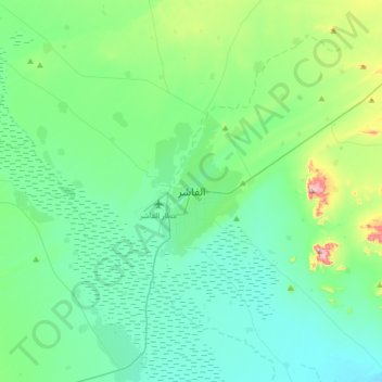
Nom : Carte topographique Al-Fashir, altitude, relief.
Lieu : Al-Fashir, Al Fasher, North Darfur State, Sudan (13.46382 25.19556 13.78382 25.51556)
Altitude moyenne : 753 m
Altitude minimum : 684 m
Altitude maximum : 1 059 m
Al Fashir, Al-Fashir or El Fasher (Arabic: الفاشر) is the capital city of North Darfur, Sudan. It is a large town in the Darfur region of northwestern Sudan, 195 kilometres (121 mi) northeast of Nyala, Sudan. A historical caravan post, Al-Fashir is located at an elevation of about 700 metres (2,300 ft). The town serves as an agricultural marketing point for the cereals and fruits grown in the surrounding region. Al-Fashir is linked by road with both Geneina and Umm Keddada. Al-Fashir had 264,734 residents as of 2006, an increase from 2001, when the population was estimated to be 178,500.
Autres cartes topographiques
Cliquez sur une carte pour visualiser sa topographie, son altitude et son relief.
Galala
Sudan > North Darfur State > Al Fasher
Galala, Al Fasher, North Darfur State, Sudan
Altitude moyenne : 919 m