
Faire un don
Équipez-vous pour votre prochaine aventure :
En tant que Partenaire Amazon, ce site perçoit une commission sur les achats éligibles sans surcoût pour vous.
Carte topographique Kohir
Cliquez sur la carte pour afficher l’altitude.
Faire un don
Équipez-vous pour votre prochaine aventure :
En tant que Partenaire Amazon, ce site perçoit une commission sur les achats éligibles sans surcoût pour vous.
Kohir
Kohir is located at 17°36′00″N 77°43′00″E / 17.6000°N 77.7167°E / 17.6000; 77.7167. It has an average elevation of 627 metres (2060 ft). It is 100 km from Hyderabad, 53 km from Bidar and 21 km from Zaheerabad.
Faire un don
Équipez-vous pour votre prochaine aventure :
En tant que Partenaire Amazon, ce site perçoit une commission sur les achats éligibles sans surcoût pour vous.
À propos de cette carte
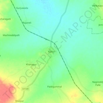
Nom : Carte topographique Kohir, altitude, relief.
Altitude moyenne : 634 m
Altitude minimum : 617 m
Altitude maximum : 669 m
Faire un don
Équipez-vous pour votre prochaine aventure :
En tant que Partenaire Amazon, ce site perçoit une commission sur les achats éligibles sans surcoût pour vous.