
Carte topographique Rocester
Cliquez sur la carte pour afficher l’altitude.
À propos de cette carte
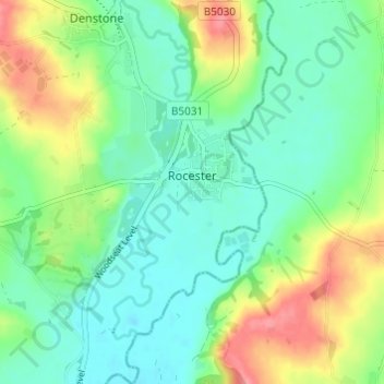
Nom : Carte topographique Rocester, altitude, relief.
Altitude moyenne : 105 m
Altitude minimum : 79 m
Altitude maximum : 156 m
Autres cartes topographiques
Cliquez sur une carte pour visualiser sa topographie, son altitude et son relief.
Tutbury Castle
United Kingdom > England > Staffordshire > East Staffordshire > Tutbury
Altitude moyenne : 66 m
Burton upon Trent
United Kingdom > England > Staffordshire > East Staffordshire
Burton is about 109 miles (175 km) north west of London, about 30 miles north east of Birmingham, the UK's second largest city and about 23 miles east of the county town Stafford. It is at the easternmost border of the county of Staffordshire with Derbyshire, its suburbs and the course of the River Trent…
Altitude moyenne : 69 m
Stubwood
United Kingdom > England > Staffordshire > East Staffordshire > Denstone
Altitude moyenne : 113 m
Birch Cross
United Kingdom > England > Staffordshire > East Staffordshire > Marchington
Altitude moyenne : 92 m
Blithfield Reservoir
United Kingdom > England > Staffordshire > East Staffordshire > Admaston
Altitude moyenne : 108 m
Gratwich
United Kingdom > England > Staffordshire > East Staffordshire > Kingstone
Altitude moyenne : 143 m
Marchington Woodlands
United Kingdom > England > Staffordshire > East Staffordshire
Altitude moyenne : 120 m
Harlow Wood
United Kingdom > England > Staffordshire > East Staffordshire > Upper Mayfield
Altitude moyenne : 177 m
Burton upon Trent
United Kingdom > England > Staffordshire > East Staffordshire
Burton is about 109 miles (175 km) north west of London, about 30 miles north east of Birmingham, the UK's second largest city and about 23 miles east of the county town Stafford. It is at the easternmost border of the county of Staffordshire with Derbyshire, its suburbs and the course of the River Trent…
Altitude moyenne : 69 m