
Carte topographique Appalachian
Carte interactive
Cliquez sur la carte pour afficher l’altitude.
À propos de cette carte
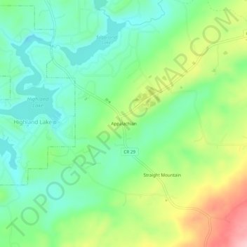
Nom : Carte topographique Appalachian, altitude, relief.
Lieu : Appalachian, Blount County, Alabama, United States (33.86482 -86.42193 33.90482 -86.38193)
Altitude moyenne : 324 m
Altitude minimum : 262 m
Altitude maximum : 443 m
Autres cartes topographiques
Cliquez sur une carte pour visualiser sa topographie, son altitude et son relief.
Sulpher Springs
United States > Alabama > Blount County
Sulpher Springs, Blount County, Alabama, United States
Altitude moyenne : 129 m
Nyota
United States > Alabama > Blount County
Nyota, Blount County, Alabama, 35172, United States
Altitude moyenne : 142 m
Snead
United States > Alabama > Blount County
Snead, Blount County, Alabama, United States
Altitude moyenne : 238 m