
Carte topographique Cuxham
Cliquez sur la carte pour afficher l’altitude.
À propos de cette carte
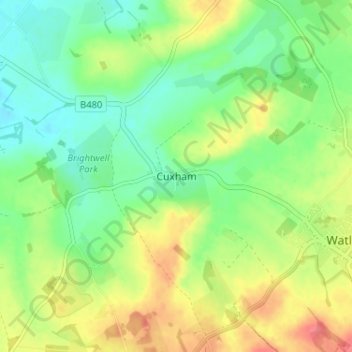
Nom : Carte topographique Cuxham, altitude, relief.
Altitude moyenne : 97 m
Altitude minimum : 70 m
Altitude maximum : 136 m
Autres cartes topographiques
Cliquez sur une carte pour visualiser sa topographie, son altitude et son relief.
Goring-on-Thames
United Kingdom > England > Oxfordshire > South Oxfordshire > Goring-on-Thames
Altitude moyenne : 87 m
Clifton Hampden
United Kingdom > England > Oxfordshire > South Oxfordshire > Clifton Hampden
Altitude moyenne : 58 m
Harpsden Wood
United Kingdom > England > Oxfordshire > South Oxfordshire > Henley-on-Thames > Harpsden
Altitude moyenne : 63 m
Watlington Hill
United Kingdom > England > Oxfordshire > South Oxfordshire > Watlington
Altitude moyenne : 189 m
Kingwood Common
United Kingdom > England > Oxfordshire > South Oxfordshire > Highmoor
Altitude moyenne : 125 m
Cowleaze Wood
United Kingdom > England > Oxfordshire > South Oxfordshire > Lewknor
Altitude moyenne : 209 m
Sonning Eye
United Kingdom > England > Oxfordshire > South Oxfordshire > Dunsden Green > Sonning Eye
Altitude moyenne : 44 m
Swyncombe
United Kingdom > England > Oxfordshire > South Oxfordshire > Swyncombe
Altitude moyenne : 174 m
Aston Rowant Nature Reserve
United Kingdom > England > Oxfordshire > South Oxfordshire > Lewknor
Altitude moyenne : 192 m
Drayton St. Leonard
United Kingdom > England > Oxfordshire > South Oxfordshire
Altitude moyenne : 54 m
Brightwell-cum-Sotwell
United Kingdom > England > Oxfordshire > South Oxfordshire
Altitude moyenne : 54 m
Kidmore End
United Kingdom > England > Oxfordshire > South Oxfordshire > Kidmore End
Altitude moyenne : 94 m
Horspath
United Kingdom > England > Oxfordshire > South Oxfordshire > Horspath
Altitude moyenne : 105 m
Chinnor Quarry 2B
United Kingdom > England > Oxfordshire > South Oxfordshire > Kingston Blount > Crowell
Altitude moyenne : 163 m
Whitchurch-on-Thames
United Kingdom > England > Oxfordshire > South Oxfordshire > Whitchurch-on-Thames
Altitude moyenne : 84 m
Edmonds Park
United Kingdom > England > Oxfordshire > South Oxfordshire > Didcot > East Hagbourne
Altitude moyenne : 68 m
Rotherfield Peppard
United Kingdom > England > Oxfordshire > South Oxfordshire > Rotherfield Peppard
Altitude moyenne : 115 m
Shirburn
United Kingdom > England > Oxfordshire > South Oxfordshire
Shirburn is a village and civil parish about 6 miles (10 km) south of Thame in Oxfordshire. It contains the Grade I listed, 14th-century Shirburn Castle, along with its surrounding, Grade II listed park, and a parish church, the oldest part of which is from the Norman period. The parish has a high altitude by…
Altitude moyenne : 140 m
East Hagbourne
United Kingdom > England > Oxfordshire > South Oxfordshire > East Hagbourne
Altitude moyenne : 62 m
Brightwell Baldwin
United Kingdom > England > Oxfordshire > South Oxfordshire > Cuxham
Altitude moyenne : 97 m
Sonning Common
United Kingdom > England > Oxfordshire > South Oxfordshire > Sonning Common
Altitude moyenne : 88 m
Stanton St John
United Kingdom > England > Oxfordshire > South Oxfordshire > Stanton St John
Altitude moyenne : 86 m
Didcot
United Kingdom > England > Oxfordshire > South Oxfordshire > East Hagbourne
Altitude moyenne : 61 m
Warborough
United Kingdom > England > Oxfordshire > South Oxfordshire > Warborough
Altitude moyenne : 53 m
Holly Wood
United Kingdom > England > Oxfordshire > South Oxfordshire > Stanton St John
Altitude moyenne : 80 m
Drayton St. Leonard
United Kingdom > England > Oxfordshire > South Oxfordshire
Altitude moyenne : 54 m