
Carte topographique Mount Rainier
Carte interactive
Cliquez sur la carte pour afficher l’altitude.
À propos de cette carte
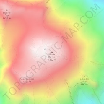
Nom : Carte topographique Mount Rainier, altitude, relief.
Lieu : Mount Rainier, Pierce County, Washington, United States (46.85210 -121.75773 46.85220 -121.75763)
Altitude moyenne : 3 912 m
Altitude minimum : 3 157 m
Altitude maximum : 4 378 m
Mount Rainier (/reɪˈnɪər/), indigenously known as Tahoma, Tacoma, Tacobet, or təqʷubəʔ, is a large active stratovolcano in the Cascade Range of the Pacific Northwest, located in Mount Rainier National Park about 59 miles (95 km) south-southeast of Seattle. With a summit elevation of 14,411 ft (4,392 m), it is the highest mountain in the U.S. state of Washington and the Cascade Range, the most topographically prominent mountain in the contiguous United States, and the tallest in the Cascade Volcanic Arc.
Autres cartes topographiques
Cliquez sur une carte pour visualiser sa topographie, son altitude et son relief.
Clinton Park
United States > Washington > Pierce County > Lakewood
Clinton Park, Lakewood, Pierce County, Washington, 98498, United States
Altitude moyenne : 77 m
Joint Base Lewis-McChord
United States > Washington > Pierce County
Joint Base Lewis-McChord, Pierce County, Washington, United States
Altitude moyenne : 119 m
Tacoma
United States > Washington > Pierce County
Tacoma, Pierce County, Washington, United States
Altitude moyenne : 67 m
Milton
United States > Washington > Pierce County
Milton, Pierce County, Washington, United States
Altitude moyenne : 67 m
Roy
United States > Washington > Pierce County
Roy, Pierce County, Washington, United States
Altitude moyenne : 105 m
Hillsdale
United States > Washington > Pierce County > Tacoma
Hillsdale, Tacoma, Pierce County, Washington, 98408, United States
Altitude moyenne : 114 m
Graham
United States > Washington > Pierce County
Graham, Pierce County, Washington, 09339, United States
Altitude moyenne : 205 m
Keck Observatory
United States > Washington > Pierce County > Parkland
Keck Observatory, 124th Street South, Parkland, Pierce County, Washington, 98447, United States
Altitude moyenne : 96 m
Puyallup
United States > Washington > Pierce County
Puyallup, Pierce County, Washington, United States
Altitude moyenne : 66 m
Frederickson
United States > Washington > Pierce County
Frederickson, Pierce County, Washington, 98387, United States
Altitude moyenne : 134 m
Edgewood
United States > Washington > Pierce County
Edgewood, Pierce County, Washington, United States
Altitude moyenne : 72 m
Home
United States > Washington > Pierce County
Home, Pierce County, Washington, United States
Altitude moyenne : 32 m
Fife
United States > Washington > Pierce County
Fife, Pierce County, Washington, 98424, United States
Altitude moyenne : 20 m
Ohop Bob
United States > Washington > Pierce County
Ohop Bob, Pierce County, Washington, 98328, United States
Altitude moyenne : 205 m
Meeker
United States > Washington > Pierce County > Puyallup
Meeker, Puyallup, Pierce County, Washington, 98372, United States
Altitude moyenne : 40 m
Lakewood
United States > Washington > Pierce County
Lakewood, Pierce County, Washington, United States
Altitude moyenne : 81 m
Steilacoom
United States > Washington > Pierce County
Steilacoom, Pierce County, Washington, 98388, United States
Altitude moyenne : 37 m
Tacoma Narrows
United States > Washington > Pierce County > Gig Harbor
Tacoma Narrows, Gig Harbor, Pierce County, Washington, United States
Altitude moyenne : 47 m
Gig Harbor
United States > Washington > Pierce County > Gig Harbor > Gig Harbor
Gig Harbor, Pierce County, Washington, 98335, United States
Altitude moyenne : 49 m
Elbe
United States > Washington > Pierce County
Elbe, Pierce County, Washington, United States
Altitude moyenne : 439 m
Puyallup
United States > Washington > Pierce County > Puyallup > Puyallup
Puyallup, Pierce County, Washington, 98371-6908, United States
Altitude moyenne : 67 m
Longbranch
United States > Washington > Pierce County > Longbranch
Longbranch, Pierce County, Washington, 98351, United States
Altitude moyenne : 37 m
Lakewood
United States > Washington > Pierce County > Lakewood > Lakewood
Lakewood, Pierce County, Washington, 98499-1705, United States
Altitude moyenne : 80 m
Anderson Island
United States > Washington > Pierce County
Anderson Island, Pierce County, Washington, 98303, United States
Altitude moyenne : 20 m
University Place
United States > Washington > Pierce County > Tacoma
University Place, Tacoma, Pierce County, Washington, 98466, United States
Altitude moyenne : 58 m
Greenwater
United States > Washington > Pierce County
Greenwater, Pierce County, Washington, United States
Altitude moyenne : 655 m
Ashford
United States > Washington > Pierce County
Ashford, Pierce County, Washington, 98330, United States
Altitude moyenne : 661 m
Gig Harbor
United States > Washington > Pierce County
Gig Harbor, Pierce County, Washington, 98335, United States
Altitude moyenne : 49 m
Buckley
United States > Washington > Pierce County
Buckley, Pierce County, Washington, United States
Altitude moyenne : 222 m