
Carte topographique Mardan
Carte interactive
Cliquez sur la carte pour afficher l’altitude.
À propos de cette carte
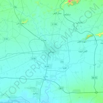
Nom : Carte topographique Mardan, altitude, relief.
Altitude moyenne : 328 m
Altitude minimum : 284 m
Altitude maximum : 894 m
Mardan is located in the south west of the district at 34°12'0N 72°1'60E and an altitude of 283 metres (928 ft). Mardan is a district headquarter of Mardan District of Khyber Pakhtunkhwa. Risalpur is located to the south, Charsadda is located to the west, Yar Hussain to the east and Takht Bahi & Katlang to the north. It is the second largest city in Khyber Pakhtunkhwa while 19th largest city of Pakistan.
Autres cartes topographiques
Cliquez sur une carte pour visualiser sa topographie, son altitude et son relief.
Sawal Dher
Pakistan > Khyber Pakhtunkhwa > Mardān District
Sawal Dher, Mardan Tehsil, Mardan District, Mardan Division, Khyber Pakhtunkhwa, Pakistan
Altitude moyenne : 358 m
Surkawai Kalay
Pakistan > Khyber Pakhtunkhwa > Mardān District > Surkawai Kalay
Surkawai Kalay, Mardān District, Khyber Pakhtunkhwa, Pakistan
Altitude moyenne : 534 m
Shewa
Pakistan > Khyber Pakhtunkhwa > Mardān District
Shewa, Mardān District, Khyber Pakhtunkhwa, Pakistan
Altitude moyenne : 370 m