
Carte topographique Linvale
Carte interactive
Cliquez sur la carte pour afficher l’altitude.
À propos de cette carte
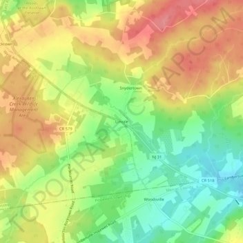
Nom : Carte topographique Linvale, altitude, relief.
Altitude moyenne : 109 m
Altitude minimum : 62 m
Altitude maximum : 152 m
Autres cartes topographiques
Cliquez sur une carte pour visualiser sa topographie, son altitude et son relief.
Bowne
United States > New Jersey > Hunterdon County > East Amwell Township
Bowne, East Amwell Township, Hunterdon County, New Jersey, United States
Altitude moyenne : 74 m
Larisons Corners
United States > New Jersey > Hunterdon County > East Amwell Township
Larisons Corners, East Amwell Township, Hunterdon County, New Jersey, 08551, United States
Altitude moyenne : 66 m
Snydertown
United States > New Jersey > Hunterdon County > East Amwell Township
Snydertown, East Amwell Township, Hunterdon County, New Jersey, 08551, United States
Altitude moyenne : 110 m
Wertsville
United States > New Jersey > Hunterdon County > East Amwell Township
Wertsville, East Amwell Township, Hunterdon County, New Jersey, United States
Altitude moyenne : 72 m
Ringoes
United States > New Jersey > Hunterdon County > East Amwell Township
Ringoes, East Amwell Township, Hunterdon County, New Jersey, 08551, United States
Altitude moyenne : 75 m
Rileyville
United States > New Jersey > Hunterdon County > East Amwell Township
Rileyville, East Amwell Township, Hunterdon County, New Jersey, 08525, United States
Altitude moyenne : 125 m