
Faire un don
Équipez-vous pour votre prochaine aventure :
En tant que Partenaire Amazon, ce site perçoit une commission sur les achats éligibles sans surcoût pour vous.
Carte topographique Randolph
Cliquez sur la carte pour afficher l’altitude.
Faire un don
Équipez-vous pour votre prochaine aventure :
En tant que Partenaire Amazon, ce site perçoit une commission sur les achats éligibles sans surcoût pour vous.
À propos de cette carte
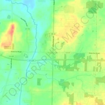
Nom : Carte topographique Randolph, altitude, relief.
Altitude moyenne : 350 m
Altitude minimum : 328 m
Altitude maximum : 378 m
Faire un don
Équipez-vous pour votre prochaine aventure :
En tant que Partenaire Amazon, ce site perçoit une commission sur les achats éligibles sans surcoût pour vous.
Autres cartes topographiques
Cliquez sur une carte pour visualiser sa topographie, son altitude et son relief.
Kent
United States > Ohio > Portage County
Located on the western end of the Glaciated Allegheny Plateau, the topography of Kent includes rolling hills and varied terrain. The Cuyahoga River passes through the city, cutting a gorge with a drop of nearly 40 feet (10 m) adjacent to the downtown area. The United States Geological Survey lists the city's…
Altitude moyenne : 328 m
Faire un don
Équipez-vous pour votre prochaine aventure :
En tant que Partenaire Amazon, ce site perçoit une commission sur les achats éligibles sans surcoût pour vous.
Faire un don
Équipez-vous pour votre prochaine aventure :
En tant que Partenaire Amazon, ce site perçoit une commission sur les achats éligibles sans surcoût pour vous.
Faire un don
Équipez-vous pour votre prochaine aventure :
En tant que Partenaire Amazon, ce site perçoit une commission sur les achats éligibles sans surcoût pour vous.
Kent
United States > Ohio > Portage County
Located on the western end of the Glaciated Allegheny Plateau, the topography of Kent includes rolling hills and varied terrain. The Cuyahoga River passes through the city, cutting a gorge with a drop of nearly 40 feet (10 m) adjacent to the downtown area. The United States Geological Survey lists the city's…
Altitude moyenne : 328 m
Faire un don
Équipez-vous pour votre prochaine aventure :
En tant que Partenaire Amazon, ce site perçoit une commission sur les achats éligibles sans surcoût pour vous.