
Carte topographique Forest Glen
Carte interactive
Cliquez sur la carte pour afficher l’altitude.
À propos de cette carte
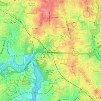
Nom : Carte topographique Forest Glen, altitude, relief.
Altitude moyenne : 96 m
Altitude minimum : 53 m
Altitude maximum : 135 m
Autres cartes topographiques
Cliquez sur une carte pour visualiser sa topographie, son altitude et son relief.
Forest Glen
United States > Maryland > Montgomery County > Forest Glen > McKenney Hills
Forest Glen, McKenney Hills, Forest Glen, Montgomery County, Maryland, United States
Altitude moyenne : 105 m
Gaithersburg
United States > Maryland > Montgomery County
Gaithersburg, Montgomery County, Maryland, United States
Altitude moyenne : 137 m
Rockville
United States > Maryland > Montgomery County
Rockville, Montgomery County, Maryland, United States
Altitude moyenne : 122 m
Germantown
United States > Maryland > Montgomery County > Germantown
Germantown, Montgomery County, Maryland, United States
Altitude moyenne : 130 m
Redland
United States > Maryland > Montgomery County
Redland, Montgomery County, Maryland, 20855, United States
Altitude moyenne : 139 m
Damascus
United States > Maryland > Montgomery County > Damascus
Damascus, Montgomery County, Maryland, 20872, United States
Altitude moyenne : 195 m