
Faire un don
Équipez-vous pour votre prochaine aventure :
En tant que Partenaire Amazon, ce site perçoit une commission sur les achats éligibles sans surcoût pour vous.
Carte topographique Lake San Cristobal
Cliquez sur la carte pour afficher l’altitude.
Faire un don
Équipez-vous pour votre prochaine aventure :
En tant que Partenaire Amazon, ce site perçoit une commission sur les achats éligibles sans surcoût pour vous.
Lake San Cristobal
Lake San Cristobal is a lake in the U.S. state of Colorado. Located in the San Juan Mountains at an elevation of 9,003 feet (2,744 m), the freshwater lake is 2.1 miles (3.4 km) long, up to 89 feet (27 m) deep, has a surface area of 0.52 square miles (1.3 km2), and holds about 11,000 acre-feet (14,000,000 m3) of water. The town of Lake City, a few miles to the north, is named after Lake San Cristobal. The name San Cristóbal means Saint Christopher in the Spanish language. Many old silver mines are near the lake and it is very clean and well kept, and stocked with Rainbow Trout.
Faire un don
Équipez-vous pour votre prochaine aventure :
En tant que Partenaire Amazon, ce site perçoit une commission sur les achats éligibles sans surcoût pour vous.
À propos de cette carte
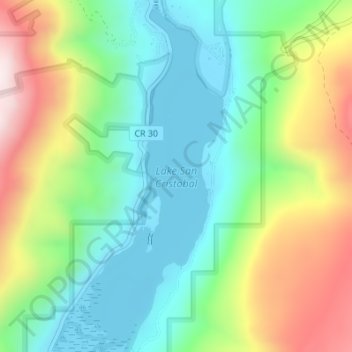
Nom : Carte topographique Lake San Cristobal, altitude, relief.
Altitude moyenne : 2 947 m
Altitude minimum : 2 744 m
Altitude maximum : 3 326 m
Faire un don
Équipez-vous pour votre prochaine aventure :
En tant que Partenaire Amazon, ce site perçoit une commission sur les achats éligibles sans surcoût pour vous.
Autres cartes topographiques
Cliquez sur une carte pour visualiser sa topographie, son altitude et son relief.
Faire un don
Équipez-vous pour votre prochaine aventure :
En tant que Partenaire Amazon, ce site perçoit une commission sur les achats éligibles sans surcoût pour vous.