
Carte topographique Sulthanbathery
Carte interactive
Cliquez sur la carte pour afficher l’altitude.
À propos de cette carte
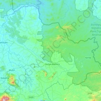
Nom : Carte topographique Sulthanbathery, altitude, relief.
Lieu : Sulthanbathery, Wayanad, Kerala, India (11.55087 76.07507 11.87263 76.44353)
Altitude moyenne : 836 m
Altitude minimum : 693 m
Altitude maximum : 1 798 m
Autres cartes topographiques
Cliquez sur une carte pour visualiser sa topographie, son altitude et son relief.
Kuruva Island
India > Kerala > Sulthanbathery
Kuruva Island, Sulthanbathery, Wayanad District, Kerala, India
Altitude moyenne : 733 m
Kenichira
India > Kerala > Sulthanbathery
Kenichira, Sulthanbathery, Wayanad District, Kerala, 673596, India
Altitude moyenne : 770 m
Nambikolly
India > Kerala > Sulthanbathery
Nambikolly, Sulthanbathery, Wayanad, Kerala, 673595, India
Altitude moyenne : 873 m
Ambalavayal
India > Kerala > Sulthanbathery > Ambalavayal
Ambalavayal, Sulthanbathery, Wayanad, Kerala, 673593, India
Altitude moyenne : 880 m
Meenangadi
India > Kerala > Sulthanbathery > Meenangadi
Meenangadi, Sulthanbathery, Wayanad, Kerala, 673591, India
Altitude moyenne : 785 m