
Faire un don
Équipez-vous pour votre prochaine aventure :
En tant que Partenaire Amazon, ce site perçoit une commission sur les achats éligibles sans surcoût pour vous.
Carte topographique Arbutus Lake
Cliquez sur la carte pour afficher l’altitude.
Faire un don
Équipez-vous pour votre prochaine aventure :
En tant que Partenaire Amazon, ce site perçoit une commission sur les achats éligibles sans surcoût pour vous.
À propos de cette carte
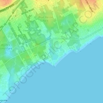
Nom : Carte topographique Arbutus Lake, altitude, relief.
Lieu : Arbutus Lake, Staten Island, New York, United States (40.52120 -74.17932 40.52554 -74.17651)
Altitude moyenne : 9 m
Altitude minimum : 0 m
Altitude maximum : 35 m
Faire un don
Équipez-vous pour votre prochaine aventure :
En tant que Partenaire Amazon, ce site perçoit une commission sur les achats éligibles sans surcoût pour vous.
Autres cartes topographiques
Cliquez sur une carte pour visualiser sa topographie, son altitude et son relief.
Washington Heights
United States > New York > New York
Because of their abrupt, hilly topography, pedestrian navigation in Upper Manhattan is facilitated by many step streets. The longest of these in Washington Heights, at approximately 130 stairs and with an elevation gain of approximately 65 feet, connects Fort Washington Avenue and Overlook Terrace at 187th…
Altitude moyenne : 25 m
Faire un don
Équipez-vous pour votre prochaine aventure :
En tant que Partenaire Amazon, ce site perçoit une commission sur les achats éligibles sans surcoût pour vous.
Manhattan Island
United States > New York > New York
Marble Hill is one example of how Manhattan's land has been considerably altered by human intervention. The borough has seen substantial land reclamation along its waterfronts since Dutch colonial times, and much of the natural variation in its topography has been evened out.
Altitude moyenne : 17 m
Faire un don
Équipez-vous pour votre prochaine aventure :
En tant que Partenaire Amazon, ce site perçoit une commission sur les achats éligibles sans surcoût pour vous.