
Faire un don
Équipez-vous pour votre prochaine aventure :
En tant que Partenaire Amazon, ce site perçoit une commission sur les achats éligibles sans surcoût pour vous.
Carte topographique Greenbank
Cliquez sur la carte pour afficher l’altitude.
Faire un don
Équipez-vous pour votre prochaine aventure :
En tant que Partenaire Amazon, ce site perçoit une commission sur les achats éligibles sans surcoût pour vous.
À propos de cette carte
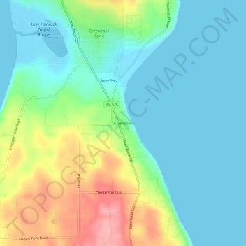
Nom : Carte topographique Greenbank, altitude, relief.
Lieu : Greenbank, Island County, Washington, 98253, United States (48.07857 -122.59215 48.11857 -122.55215)
Altitude moyenne : 39 m
Altitude minimum : -2 m
Altitude maximum : 136 m
Faire un don
Équipez-vous pour votre prochaine aventure :
En tant que Partenaire Amazon, ce site perçoit une commission sur les achats éligibles sans surcoût pour vous.
Autres cartes topographiques
Cliquez sur une carte pour visualiser sa topographie, son altitude et son relief.
Whidbey Island
United States > Washington > Island County
Whidbey Island features a diverse topography characterized by a mix of rolling hills, lush forests, and dramatic coastal cliffs. The island stretches approximately 55 miles in length and up to 12 miles wide, rising to elevations of about 500 feet at its highest point. Its terrain includes expansive farmland…
Altitude moyenne : 45 m
Faire un don
Équipez-vous pour votre prochaine aventure :
En tant que Partenaire Amazon, ce site perçoit une commission sur les achats éligibles sans surcoût pour vous.
Whidbey Island
United States > Washington > Island County
Whidbey Island lies partially in the rain shadow of the Olympic Mountain Range to the west, and has a variety of climate zones. This can be observed by rainfall amounts – wettest in the south with average rainfall of 36 inches (910 mm), driest in the central district of Coupeville with average rainfall of 20…
Altitude moyenne : 45 m
Faire un don
Équipez-vous pour votre prochaine aventure :
En tant que Partenaire Amazon, ce site perçoit une commission sur les achats éligibles sans surcoût pour vous.