
Carte topographique Lough Foyle
Carte interactive
Cliquez sur la carte pour afficher l’altitude.
À propos de cette carte
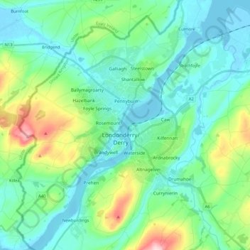
Nom : Carte topographique Lough Foyle, altitude, relief.
Altitude moyenne : 61 m
Altitude minimum : -4 m
Altitude maximum : 279 m
Autres cartes topographiques
Cliquez sur une carte pour visualiser sa topographie, son altitude et son relief.
Campsey
United Kingdom > Northern Ireland > County Londonderry > Londonderry/Derry
Campsey, Londonderry/Derry, County Londonderry, Northern Ireland, BT47 3PA, United Kingdom
Altitude moyenne : 26 m