
Faire un don
Équipez-vous pour votre prochaine aventure :
En tant que Partenaire Amazon, ce site perçoit une commission sur les achats éligibles sans surcoût pour vous.
Carte topographique Export
Cliquez sur la carte pour afficher l’altitude.
Faire un don
Équipez-vous pour votre prochaine aventure :
En tant que Partenaire Amazon, ce site perçoit une commission sur les achats éligibles sans surcoût pour vous.
Export
Export is characterized by a varied terrain that reflects its location in the Allegheny Plateau region. The borough sits at an average elevation of around 1,122 feet (342 meters) and features rolling hills and valleys typical of southwestern Pennsylvania's topography. The surrounding landscape is marked by gentle slopes and a mix of wooded areas and open fields, providing a picturesque setting that transitions into more rugged terrain as you move toward the nearby hills. The area is also influenced by local waterways, which have carved out small valleys and contribute to the region's rich biodiversity.
Faire un don
Équipez-vous pour votre prochaine aventure :
En tant que Partenaire Amazon, ce site perçoit une commission sur les achats éligibles sans surcoût pour vous.
À propos de cette carte
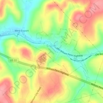
Nom : Carte topographique Export, altitude, relief.
Altitude moyenne : 342 m
Altitude minimum : 289 m
Altitude maximum : 393 m
Faire un don
Équipez-vous pour votre prochaine aventure :
En tant que Partenaire Amazon, ce site perçoit une commission sur les achats éligibles sans surcoût pour vous.
Autres cartes topographiques
Cliquez sur une carte pour visualiser sa topographie, son altitude et son relief.
Donegal Lake
United States > Pennsylvania > Westmoreland County > Donegal Township
Altitude moyenne : 493 m
Circleville
United States > Pennsylvania > Westmoreland County > North Huntingdon Township
Altitude moyenne : 333 m
Twin Lakes Park
United States > Pennsylvania > Westmoreland County > Hempfield Township > Luxor > Georges Station
Altitude moyenne : 367 m
Faire un don
Équipez-vous pour votre prochaine aventure :
En tant que Partenaire Amazon, ce site perçoit une commission sur les achats éligibles sans surcoût pour vous.
Perryville
United States > Pennsylvania > Westmoreland County > Bell Township
Altitude moyenne : 365 m
Chestnut Ridge
United States > Pennsylvania > Westmoreland County > Fairfield Township
Altitude moyenne : 466 m
Morewood
United States > Pennsylvania > Westmoreland County > East Huntingdon Township
Altitude moyenne : 357 m
Faire un don
Équipez-vous pour votre prochaine aventure :
En tant que Partenaire Amazon, ce site perçoit une commission sur les achats éligibles sans surcoût pour vous.
United
United States > Pennsylvania > Westmoreland County > Mount Pleasant Township
Altitude moyenne : 326 m
Turkeytown
United States > Pennsylvania > Westmoreland County > South Huntingdon Township
Altitude moyenne : 317 m
Buckeye
United States > Pennsylvania > Westmoreland County > East Huntingdon Township
Altitude moyenne : 338 m
Faire un don
Équipez-vous pour votre prochaine aventure :
En tant que Partenaire Amazon, ce site perçoit une commission sur les achats éligibles sans surcoût pour vous.
Alverton
United States > Pennsylvania > Westmoreland County > East Huntingdon Township
Altitude moyenne : 361 m
Tarrs
United States > Pennsylvania > Westmoreland County > East Huntingdon Township
Altitude moyenne : 356 m
Acme
United States > Pennsylvania > Westmoreland County > Mount Pleasant Township
Altitude moyenne : 585 m
Collinsburg
United States > Pennsylvania > Westmoreland County > Rostraver Township
Altitude moyenne : 282 m
Faire un don
Équipez-vous pour votre prochaine aventure :
En tant que Partenaire Amazon, ce site perçoit une commission sur les achats éligibles sans surcoût pour vous.
Painter Rock Hill
United States > Pennsylvania > Westmoreland County > Donegal Township
Altitude moyenne : 781 m
Stahlstown
United States > Pennsylvania > Westmoreland County > Cook Township
Altitude moyenne : 514 m
Bessemer
United States > Pennsylvania > Westmoreland County > East Huntingdon Township
Altitude moyenne : 342 m
Faire un don
Équipez-vous pour votre prochaine aventure :
En tant que Partenaire Amazon, ce site perçoit une commission sur les achats éligibles sans surcoût pour vous.
Southwest
United States > Pennsylvania > Westmoreland County > Mount Pleasant Township
Altitude moyenne : 336 m
Maplewood Terrace
United States > Pennsylvania > Westmoreland County > Hempfield Township > Maplewood Terrace
Altitude moyenne : 346 m
Bessemer
United States > Pennsylvania > Westmoreland County > East Huntingdon Township > Bessemer
Altitude moyenne : 342 m
Camp Jo-Ann
United States > Pennsylvania > Westmoreland County > Murrysville > Camp Jo-Ann
Altitude moyenne : 343 m
Faire un don
Équipez-vous pour votre prochaine aventure :
En tant que Partenaire Amazon, ce site perçoit une commission sur les achats éligibles sans surcoût pour vous.
Keystone State Park
United States > Pennsylvania > Westmoreland County > Derry Township
Altitude moyenne : 352 m
Yukon
United States > Pennsylvania > Westmoreland County > South Huntingdon Township
Altitude moyenne : 315 m