
Faire un don
Équipez-vous pour votre prochaine aventure :
En tant que Partenaire Amazon, ce site perçoit une commission sur les achats éligibles sans surcoût pour vous.
Carte topographique Zafririm
Cliquez sur la carte pour afficher l’altitude.
Faire un don
Équipez-vous pour votre prochaine aventure :
En tant que Partenaire Amazon, ce site perçoit une commission sur les achats éligibles sans surcoût pour vous.
À propos de cette carte
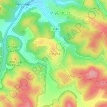
Nom : Carte topographique Zafririm, altitude, relief.
Altitude moyenne : 322 m
Altitude minimum : 265 m
Altitude maximum : 382 m
Faire un don
Équipez-vous pour votre prochaine aventure :
En tant que Partenaire Amazon, ce site perçoit une commission sur les achats éligibles sans surcoût pour vous.
Autres cartes topographiques
Cliquez sur une carte pour visualiser sa topographie, son altitude et son relief.
Zecharya
Israel > Jerusalem District > Mate Yehuda Regional Council
The Tell rests upon a high hilltop, whereas the village lay on a slightly elevated part of the valley below, on the northwest side of the hill. The hill rises to a maximum elevation of 372 meters above sea level, with a mean elevation of approximately 275 meters above sea level. The village lay next to the…
Altitude moyenne : 278 m
Faire un don
Équipez-vous pour votre prochaine aventure :
En tant que Partenaire Amazon, ce site perçoit une commission sur les achats éligibles sans surcoût pour vous.
Faire un don
Équipez-vous pour votre prochaine aventure :
En tant que Partenaire Amazon, ce site perçoit une commission sur les achats éligibles sans surcoût pour vous.