
Faire un don
Équipez-vous pour votre prochaine aventure :
En tant que Partenaire Amazon, ce site perçoit une commission sur les achats éligibles sans surcoût pour vous.
Carte topographique Hutto
Cliquez sur la carte pour afficher l’altitude.
Faire un don
Équipez-vous pour votre prochaine aventure :
En tant que Partenaire Amazon, ce site perçoit une commission sur les achats éligibles sans surcoût pour vous.
À propos de cette carte
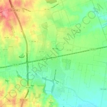
Nom : Carte topographique Hutto, altitude, relief.
Lieu : Hutto, Williamson County, Texas, 78634, United States (30.49462 -97.58344 30.59851 -97.48449)
Altitude moyenne : 204 m
Altitude minimum : 171 m
Altitude maximum : 259 m
Faire un don
Équipez-vous pour votre prochaine aventure :
En tant que Partenaire Amazon, ce site perçoit une commission sur les achats éligibles sans surcoût pour vous.
Autres cartes topographiques
Cliquez sur une carte pour visualiser sa topographie, son altitude et son relief.
Soil Conservation Service Site 12 Dam
United States > Texas > Williamson County > Type
Altitude moyenne : 173 m
Soil Conservation Service Site 12 Dam
United States > Texas > Williamson County > Type
Altitude moyenne : 173 m
Faire un don
Équipez-vous pour votre prochaine aventure :
En tant que Partenaire Amazon, ce site perçoit une commission sur les achats éligibles sans surcoût pour vous.
Soil Conservation Service Site 12 Dam
United States > Texas > Williamson County > Type
Altitude moyenne : 173 m
Georgetown
United States > Texas > Williamson County > Georgetown
The city is located on the northeastern edge of Texas Hill Country. Portions of Georgetown are located on either side of the Balcones Escarpment, a fault line in which the areas roughly east of IH-35 are flat and characterized by having black, fertile soils of the Blackland Prairie, and the west side of the…
Altitude moyenne : 228 m
Cedar Park
United States > Texas > Williamson County > Cedar Park > Cedar Park
Altitude moyenne : 292 m
Faire un don
Équipez-vous pour votre prochaine aventure :
En tant que Partenaire Amazon, ce site perçoit une commission sur les achats éligibles sans surcoût pour vous.
Round Rock
United States > Texas > Williamson County > Round Rock
The city straddles the Balcones Escarpment, a fault line in which the areas roughly east of Interstate 35 are flat and characterized by having black, fertile soils of the Blackland Prairie, and the west side of the Escarpment, which consists mostly of hilly, karst-like terrain with little topsoil and higher…
Altitude moyenne : 236 m