
Carte topographique Valley Creek Junction
Carte interactive
Cliquez sur la carte pour afficher l’altitude.
À propos de cette carte
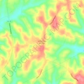
Nom : Carte topographique Valley Creek Junction, altitude, relief.
Lieu : Valley Creek Junction, Dallas County, Alabama, United States (32.54847 -86.96888 32.58847 -86.92888)
Altitude moyenne : 115 m
Altitude minimum : 70 m
Altitude maximum : 157 m
Autres cartes topographiques
Cliquez sur une carte pour visualiser sa topographie, son altitude et son relief.
Selmont–West Selmont
United States > Alabama > Dallas County
Selmont–West Selmont, Dallas County, Alabama, 36702, United States
Altitude moyenne : 35 m
Elm Bluff
United States > Alabama > Dallas County
Elm Bluff, Dallas County, Alabama, United States
Altitude moyenne : 88 m
Plantersville
United States > Alabama > Dallas County
Plantersville, Dallas County, Alabama, 36758, United States
Altitude moyenne : 89 m
Orrville
United States > Alabama > Dallas County > Orrville
Orrville, Dallas County, Alabama, United States
Altitude moyenne : 57 m
Valley Grande
United States > Alabama > Dallas County > Valley Grande
Valley Grande, Dallas County, Alabama, United States
Altitude moyenne : 101 m
Sunset Mill Village
United States > Alabama > Dallas County > Selma > Sunset Mill Village
Sunset Mill Village, Selma, Dallas County, Alabama, 36701, United States
Altitude moyenne : 38 m