
Carte topographique Jenkinson Lake
Cliquez sur la carte pour afficher l’altitude.
À propos de cette carte
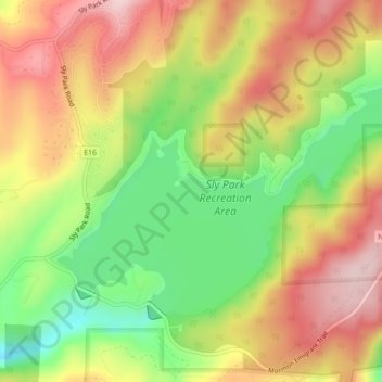
Nom : Carte topographique Jenkinson Lake, altitude, relief.
Altitude moyenne : 1 130 m
Altitude minimum : 986 m
Altitude maximum : 1 265 m
Autres cartes topographiques
Cliquez sur une carte pour visualiser sa topographie, son altitude et son relief.
Diamond Springs
United States > California > El Dorado County
Diamond Springs (formerly, Diamond Spring and Diamond) is a census-designated place (CDP) in El Dorado County, California, United States. It is part of the Sacramento–Arden-Arcade–Roseville Metropolitan Statistical Area. The population was 11,037 at the 2010 census, up from 4,888 at the 2000 census. The…
Altitude moyenne : 542 m
Meyers
United States > California > El Dorado County
Meyers (also Yanks, Yank's Station, and Tahoe Paradise) is a small an unincorporated community and census-designated place (CDP) in El Dorado County, California, United States, along U.S. Route 50 in the northern Sierra Nevada. It is 6 miles (10 km) south of South Lake Tahoe in the Lake Tahoe area and lies at…
Altitude moyenne : 1 995 m
El Dorado Hills
United States > California > El Dorado County > Cameron Park
El Dorado Hills (EDH), as defined by the 2010 census-designated place (CDP), is at the western border of El Dorado County, between the City of Folsom and the unincorporated community of Cameron Park. The northern limits of the CDP are Folsom Lake and the South Fork of the American River, where river rafters…
Altitude moyenne : 254 m
Pollock Pines
United States > California > El Dorado County > Pollock Pines
Pollock Pines is a census-designated place (CDP) in El Dorado County, California, United States. It is part of the Sacramento–Arden-Arcade–Roseville Metropolitan Statistical Area. Pollock Pines lies at an elevation of 3,980 feet (1,210 m) in the Sierra Nevada. The population was 6,871 at the 2010 census,…
Altitude moyenne : 1 118 m
Cameron Park
United States > California > El Dorado County > Cameron Park
Cameron Park is situated in an interior chaparral zone or brush zone just east of the Central Valley. It is the closest population center to the Pine Hill Ecological Reserve. Native vegetation includes an abundance of redbud and manzanita bushes, and brush in general. Where treed the native trees are primarily…
Altitude moyenne : 409 m
Rescue
United States > California > El Dorado County > Cameron Park
Rescue, formerly Green Valley, El Dorado County, California, is an unincorporated community in El Dorado County, California. It is located north-northwest of Shingle Springs and north-northeast of Cameron Park. The zip code is 95672, and Rescue is located in area code 530. The town lies at an elevation of 1214…
Altitude moyenne : 393 m
Baltic Peak
United States > California > El Dorado County
Baltic Peak is a mountain in the Sierra Nevada foothills of El Dorado County in the U.S. state of California. The nearest city to this peak is Grizzly Flats, a small unincorporated community. Branching off of the Mormon Emigrant Trail, which can be found 3.4 miles from Jenkinson Lake, a dirt path can be found…
Altitude moyenne : 1 380 m
Cameron Park
United States > California > El Dorado County
Cameron Park is situated in an interior chaparral zone or brush zone just east of the Central Valley. It is the closest population center to the Pine Hill Ecological Reserve. Native vegetation includes an abundance of redbud and manzanita bushes, and brush in general. Where treed the native trees are primarily…
Altitude moyenne : 409 m
El Dorado Hills
United States > California > El Dorado County > Cameron Park
El Dorado Hills (EDH), as defined by the 2010 census-designated place (CDP), is at the western border of El Dorado County, between the City of Folsom and the unincorporated community of Cameron Park. The northern limits of the CDP are Folsom Lake and the South Fork of the American River, where river rafters…
Altitude moyenne : 252 m
Cameron Park
United States > California > El Dorado County
Cameron Park is situated in an interior chaparral zone or brush zone just east of the Central Valley. It is the closest population center to the Pine Hill Ecological Reserve. Native vegetation includes an abundance of redbud and manzanita bushes, and brush in general. Where treed the native trees are primarily…
Altitude moyenne : 390 m
Rescue
United States > California > El Dorado County
Rescue is an unincorporated community in El Dorado County, California. It is located north-northwest of Shingle Springs and north-northeast of Cameron Park. The zip code is 95672, and Rescue is located in area code 530. The town lies at an elevation of 1214 feet (370 m).
Altitude moyenne : 393 m
Diamond Springs
United States > California > El Dorado County
Diamond Springs (formerly, Diamond Spring and Diamond) is a census-designated place (CDP) in El Dorado County, California, United States. It is part of the Sacramento–Arden-Arcade–Roseville Metropolitan Statistical Area. The population was 11,037 at the 2010 census, up from 4,888 at the 2000 census. The…
Altitude moyenne : 531 m
El Dorado Hills
United States > California > El Dorado County > Folsom
El Dorado Hills (EDH), as defined by the 2010 census-designated place (CDP), is at the western border of El Dorado County, between the City of Folsom and the unincorporated community of Cameron Park. The northern limits of the CDP are Folsom Lake and the South Fork of the American River, where river rafters…
Altitude moyenne : 243 m
Cameron Park
United States > California > El Dorado County
Cameron Park is situated in an interior chaparral zone or brush zone just east of the Central Valley. It is the closest population center to the Pine Hill Ecological Reserve. Native vegetation includes an abundance of redbud and manzanita bushes, and brush in general. Where treed the native trees are primarily…
Altitude moyenne : 409 m
Cameron Park
United States > California > El Dorado County > Cameron Park
Cameron Park is situated in an interior chaparral zone or brush zone just east of the Central Valley. It is the closest population center to the Pine Hill Ecological Reserve. Native vegetation includes an abundance of redbud and manzanita bushes, and brush in general. Where treed the native trees are primarily…
Altitude moyenne : 409 m