
Carte topographique Adrar
Carte interactive
Cliquez sur la carte pour afficher l’altitude.
À propos de cette carte
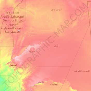
Nom : Carte topographique Adrar, altitude, relief.
Lieu : Adrar, Mauritania (18.55704 -14.30119 24.26945 -6.35410)
Altitude moyenne : 306 m
Altitude minimum : 36 m
Altitude maximum : 837 m
Mauritania is mostly covered with desert, with only its western regions around the coast of Atlantic Ocean having some vegetation. There are some oasis in the desert regions. Since it is a desert, there are large shifting dunes forming temporary ranges. The average elevation is around 460 m (1,510 ft) above the mean sea level. The rainfall in the northern regions closer to the Tropic of Cancer receives around 100 mm (3.9 in) of annual rainfall compared to the southern portions that receives around 660 mm (26 in). The average temperature is 37.8 °C (100.0 °F), while during the night it reaches 0 °C (32 °F). Due to the geography, the inhabitants historically, have been nomadic. In modern times, people have migrated to urban centres during the drought in 1970 and 1980. There are a few sedentary cultivators, who are located only in the Southern regions of the country. Research has indicated that the Saharan movement has resulted in reduction of rains in the region from the 1960s, when it received close to 250 mm (9.8 in) of rainfall.
Autres cartes topographiques
Cliquez sur une carte pour visualiser sa topographie, son altitude et son relief.
Gleib Teintane
Gleib Teintane, Tiris Zemmour, Mauritania
Altitude moyenne : 342 m
Nouakchott
Mauritania > Nouakchott-Ouest Region
Nouakchott, Nouakchott-Ouest Region, Mauritania
Altitude moyenne : 4 m
Aracham Abiod
Aracham Abiod, Tiris Zemmour, Mauritania
Altitude moyenne : 445 m
`Arafat
Mauritania > Nouakchott > `Arafat
`Arafat, Nouakchott, 00222, Mauritania
Altitude moyenne : 4 m
Kediet ej Jill
Kediet ej Jill, Tiris Zemmour, Mauritania
Altitude moyenne : 783 m
Fderîck
Mauritania > Tiris Zemmour > Fderîck
Fderîck, Tiris Zemmour, Mauritania
Altitude moyenne : 305 m