
Faire un don
Équipez-vous pour votre prochaine aventure :
En tant que Partenaire Amazon, ce site perçoit une commission sur les achats éligibles sans surcoût pour vous.
Carte topographique Meinerzhagen
Cliquez sur la carte pour afficher l’altitude.
Faire un don
Équipez-vous pour votre prochaine aventure :
En tant que Partenaire Amazon, ce site perçoit une commission sur les achats éligibles sans surcoût pour vous.
Meinerzhagen
Meinerzhagen is located in the hills of the Sauerland. The highest elevation is the Nordhelle with 652 m above sea level, the lowest elevation at the Lister dam with 319m. 56% of the town area is covered by forests.
Faire un don
Équipez-vous pour votre prochaine aventure :
En tant que Partenaire Amazon, ce site perçoit une commission sur les achats éligibles sans surcoût pour vous.
À propos de cette carte
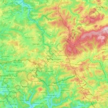
Nom : Carte topographique Meinerzhagen, altitude, relief.
Altitude moyenne : 419 m
Altitude minimum : 252 m
Altitude maximum : 664 m
Faire un don
Équipez-vous pour votre prochaine aventure :
En tant que Partenaire Amazon, ce site perçoit une commission sur les achats éligibles sans surcoût pour vous.
Autres cartes topographiques
Cliquez sur une carte pour visualiser sa topographie, son altitude et son relief.
Ebbegebirge
Germany > North Rhine-Westphalia > Märkischer Kreis > Herscheid
The highest elevation in the Ebbe Mountains is the Nordhelle (663.3 m above NN) between Valbert and Herscheid. Other notable hills are the: Rehberg (645.9 m), Rüenhardt (636.0 m), Waldberg (ca. 635 m), Rothenstein (ca. 600 m), Der Griesing (552,6 m), Homert (538,3 m) and Kahler Kopf (540.1 m).
Altitude moyenne : 550 m