
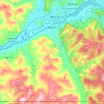
Carte topographique Town of Vestal
Carte interactive
Cliquez sur la carte pour afficher l’altitude.
À propos de cette carte
Nom : Carte topographique Town of Vestal, altitude, relief.
Altitude moyenne : 372 m
Altitude minimum : 241 m
Altitude maximum : 567 m
Autres cartes topographiques
Cliquez sur une carte pour visualiser sa topographie, son altitude et son relief.
Town of Nanticoke
United States > New York > Broome County
Town of Nanticoke, Broome County, New York, 13777, United States
Altitude moyenne : 396 m
Town of Binghamton
United States > New York > Broome County
Town of Binghamton, Broome County, New York, 13903, United States
Altitude moyenne : 417 m
Crocker Island
United States > New York > Broome County > Village of Johnson City
Crocker Island, Village of Johnson City, Town of Union, Broome County, New York, 13902, United States
Altitude moyenne : 411 m
Nineveh
United States > New York > Broome County
Nineveh, Town of Colesville, Broome County, New York, United States
Altitude moyenne : 338 m
City of Binghamton
United States > New York > Broome County
City of Binghamton, Broome County, New York, 13905, United States
Altitude moyenne : 321 m
Oquaga Lake
United States > New York > Broome County > Town of Sanford
Oquaga Lake, Town of Sanford, Broome County, New York, United States
Altitude moyenne : 515 m
Binghamton
United States > New York > Broome County > Binghamton
Binghamton, Broome County, New York, 13903, United States
Altitude moyenne : 397 m
Village of Johnson City
United States > New York > Broome County
Village of Johnson City, Town of Union, Broome County, New York, 13790, United States
Altitude moyenne : 309 m
Flowers
United States > New York > Broome County > Flowers
Flowers, Windsor Town, Broome County, New York, 13865, United States
Altitude moyenne : 484 m
Village of Deposit
United States > New York > Broome County
Village of Deposit, Town of Sanford, Broome County, New York, United States
Altitude moyenne : 356 m