
Faire un don
Équipez-vous pour votre prochaine aventure :
En tant que Partenaire Amazon, ce site perçoit une commission sur les achats éligibles sans surcoût pour vous.
Carte topographique Harwinton
Cliquez sur la carte pour afficher l’altitude.
Faire un don
Équipez-vous pour votre prochaine aventure :
En tant que Partenaire Amazon, ce site perçoit une commission sur les achats éligibles sans surcoût pour vous.
À propos de cette carte
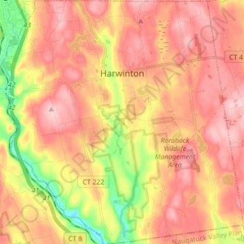
Nom : Carte topographique Harwinton, altitude, relief.
Altitude moyenne : 252 m
Altitude minimum : 117 m
Altitude maximum : 341 m
Faire un don
Équipez-vous pour votre prochaine aventure :
En tant que Partenaire Amazon, ce site perçoit une commission sur les achats éligibles sans surcoût pour vous.
Autres cartes topographiques
Cliquez sur une carte pour visualiser sa topographie, son altitude et son relief.
Apple Hill
United States > Connecticut > Northwest Hills Planning Region > Morris
Altitude moyenne : 297 m
Northfield
United States > Connecticut > Northwest Hills Planning Region > Litchfield
Altitude moyenne : 259 m
Bakerville
United States > Connecticut > Northwest Hills Planning Region > New Hartford
Altitude moyenne : 244 m
Haystack Mountain
United States > Connecticut > Northwest Hills Planning Region > Norfolk
Altitude moyenne : 385 m
Faire un don
Équipez-vous pour votre prochaine aventure :
En tant que Partenaire Amazon, ce site perçoit une commission sur les achats éligibles sans surcoût pour vous.
Marble Dale
United States > Connecticut > Northwest Hills Planning Region > Washington
Altitude moyenne : 249 m
Washington Depot
United States > Connecticut > Northwest Hills Planning Region > Washington
Altitude moyenne : 231 m
Nelsons Corner
United States > Connecticut > Northwest Hills Planning Region > Winchester
Altitude moyenne : 275 m
Nepaug
United States > Connecticut > Northwest Hills Planning Region > New Hartford
Altitude moyenne : 222 m
Faire un don
Équipez-vous pour votre prochaine aventure :
En tant que Partenaire Amazon, ce site perçoit une commission sur les achats éligibles sans surcoût pour vous.
West Torrington
United States > Connecticut > Northwest Hills Planning Region > Torrington
Altitude moyenne : 270 m
Lakeville
United States > Connecticut > Northwest Hills Planning Region > Salisbury
Altitude moyenne : 259 m
East Morris
United States > Connecticut > Northwest Hills Planning Region > Morris
Altitude moyenne : 294 m
Faire un don
Équipez-vous pour votre prochaine aventure :
En tant que Partenaire Amazon, ce site perçoit une commission sur les achats éligibles sans surcoût pour vous.
Wangum Village
United States > Connecticut > Northwest Hills Planning Region > Canaan
Altitude moyenne : 235 m
Pleasant Valley
United States > Connecticut > Northwest Hills Planning Region > Barkhamsted
Altitude moyenne : 192 m
Drakeville
United States > Connecticut > Northwest Hills Planning Region > Torrington
Altitude moyenne : 309 m
Lookout
United States > Connecticut > Northwest Hills Planning Region > Goshen
Altitude moyenne : 434 m
Faire un don
Équipez-vous pour votre prochaine aventure :
En tant que Partenaire Amazon, ce site perçoit une commission sur les achats éligibles sans surcoût pour vous.
Bartholomew Hill
United States > Connecticut > Northwest Hills Planning Region > Goshen
Altitude moyenne : 426 m
Canaan Valley
United States > Connecticut > Northwest Hills Planning Region > North Canaan
Altitude moyenne : 293 m
Bear Mountain
United States > Connecticut > Northwest Hills Planning Region > Salisbury
Bear Mountain is a peak of the southern Taconic Mountains in Salisbury, Connecticut. At 2,316 feet (706 m) (note, per references 1 and 3, there is disagreement about the precise elevation), Bear Mountain is the highest mountain that lies wholly within Connecticut. However, it is not the state highpoint: in the…
Altitude moyenne : 544 m
The Matterhorn
United States > Connecticut > Northwest Hills Planning Region > Canaan
Altitude moyenne : 462 m
Faire un don
Équipez-vous pour votre prochaine aventure :
En tant que Partenaire Amazon, ce site perçoit une commission sur les achats éligibles sans surcoût pour vous.
Bear Mountain
United States > Connecticut > Northwest Hills Planning Region > Salisbury
Bear Mountain is a peak of the southern Taconic Mountains in Salisbury, Connecticut. At 2,316 feet (706 m) (note, per references 1 and 3, there is disagreement about the precise elevation), Bear Mountain is the highest mountain that lies wholly within Connecticut. However, it is not the state highpoint: in the…
Altitude moyenne : 544 m
The Matterhorn
United States > Connecticut > Northwest Hills Planning Region > Canaan
Altitude moyenne : 462 m
Lime Rock
United States > Connecticut > Northwest Hills Planning Region > Salisbury
Altitude moyenne : 238 m
Northfield
United States > Connecticut > Northwest Hills Planning Region > Litchfield
Altitude moyenne : 259 m
Faire un don
Équipez-vous pour votre prochaine aventure :
En tant que Partenaire Amazon, ce site perçoit une commission sur les achats éligibles sans surcoût pour vous.
Bradford Mountain
United States > Connecticut > Northwest Hills Planning Region > Canaan
Altitude moyenne : 470 m
Bulls Bridge
United States > Connecticut > Northwest Hills Planning Region > Kent
Altitude moyenne : 178 m
Panorama Hill
United States > Connecticut > Northwest Hills Planning Region > Colebrook
Altitude moyenne : 379 m
Bear Mountain
United States > Connecticut > Northwest Hills Planning Region > Salisbury
Bear Mountain is a peak of the southern Taconic Mountains in Salisbury, Connecticut. At 2,316 feet (706 m) (note, per references 1 and 3, there is disagreement about the precise elevation), Bear Mountain is the highest mountain that lies wholly within Connecticut. However, it is not the state highpoint: in the…
Altitude moyenne : 544 m
Faire un don
Équipez-vous pour votre prochaine aventure :
En tant que Partenaire Amazon, ce site perçoit une commission sur les achats éligibles sans surcoût pour vous.
Town Hill
United States > Connecticut > Northwest Hills Planning Region > New Hartford
Altitude moyenne : 255 m
Torringford
United States > Connecticut > Northwest Hills Planning Region > Torrington
Altitude moyenne : 301 m
Bear Mountain
United States > Connecticut > Northwest Hills Planning Region > Salisbury
Bear Mountain is a peak of the southern Taconic Mountains in Salisbury, Connecticut. At 2,316 feet (706 m) (note, per references 1 and 3, there is disagreement about the precise elevation), Bear Mountain is the highest mountain that lies wholly within Connecticut. However, it is not the state highpoint: in the…
Altitude moyenne : 544 m
Northfield
United States > Connecticut > Northwest Hills Planning Region > Litchfield
Altitude moyenne : 259 m
Faire un don
Équipez-vous pour votre prochaine aventure :
En tant que Partenaire Amazon, ce site perçoit une commission sur les achats éligibles sans surcoût pour vous.
Grand Staircase
United States > Connecticut > Northwest Hills Planning Region > Kent
Altitude moyenne : 205 m
Milton Hill
United States > Connecticut > Northwest Hills Planning Region > Goshen
Altitude moyenne : 368 m
Apple Hill
United States > Connecticut > Northwest Hills Planning Region > Morris
Altitude moyenne : 297 m
Canaan Valley
United States > Connecticut > Northwest Hills Planning Region > North Canaan
Altitude moyenne : 293 m
Faire un don
Équipez-vous pour votre prochaine aventure :
En tant que Partenaire Amazon, ce site perçoit une commission sur les achats éligibles sans surcoût pour vous.
Burrville
United States > Connecticut > Northwest Hills Planning Region > Torrington
Altitude moyenne : 292 m