Géolocaliser

Carte topographique Farnborough

Cliquez sur la carte pour afficher l’altitude.

Farnborough

Farnborough is located in the northeastern corner of the county of Hampshire, near the border with Surrey. The town occupies a valley setting, with the main urban area situated between the River Blackwater to the east and higher ground to the west. The topography gradually rises from the valley floor, reaching a maximum elevation of around 90 metres (300 feet) above sea level on the fringes of the town.

Wikipedia (CC-BY-SA 3.0)

À propos de cette carte

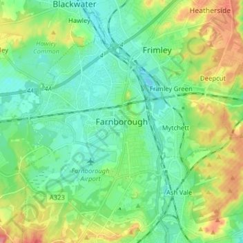
Nom : Carte topographique Farnborough, altitude, relief.

Lieu : Farnborough, Rushmoor, Hampshire, England, GU14 7JT, United Kingdom (51.25187 -0.79398 51.33187 -0.71398)

Altitude moyenne : 82 m

Altitude minimum : 57 m

Altitude maximum : 137 m

Équipez-vous pour votre prochaine aventure :

🔪Couteau de Poche - L'outil indispensable pour toutes les situations en extérieur.
Montres GPS outdoor - Montres sport avec suivi GPS, altitude et activités
🥾Guêtres de randonnée - Protection contre boue et neige
📷Caméra d'Action - Filmez vos descentes et vos explorations de terrain.
🧴Gel Hydroalcoolique - Hygiène des mains rapide avant de manger sur le pouce.

En tant que Partenaire Amazon, ce site perçoit une commission sur les achats éligibles sans surcoût pour vous.