
Carte topographique Mount Abu
Carte interactive
Cliquez sur la carte pour afficher l’altitude.
À propos de cette carte
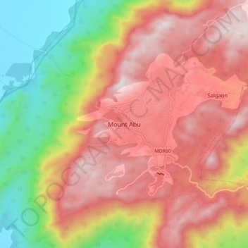
Nom : Carte topographique Mount Abu, altitude, relief.
Altitude moyenne : 914 m
Altitude minimum : 279 m
Altitude maximum : 1 422 m
Mount Abu town, the only hill station in Rajasthan, is at an elevation of 1,220 m (4,003 ft). It has been a popular retreat from the heat of Rajasthan and neighboring Gujarat for centuries.
Autres cartes topographiques
Cliquez sur une carte pour visualiser sa topographie, son altitude et son relief.
Aravalli Range
India > Rajasthan > Abu Road Tehsil
Aravalli Range, Abu Road Tehsil, Sirohi District, Rajasthan, 307501, India
Altitude moyenne : 1 339 m
Guru Shikhar, Abu
India > Rajasthan > Abu Road Tehsil
Guru Shikhar, Abu, Abu Road Tehsil, Sirohi District, Rajasthan, 307501, India
Altitude moyenne : 1 366 m