
Faire un don
Équipez-vous pour votre prochaine aventure :
En tant que Partenaire Amazon, ce site perçoit une commission sur les achats éligibles sans surcoût pour vous.
Carte topographique Piravom
Cliquez sur la carte pour afficher l’altitude.
Faire un don
Équipez-vous pour votre prochaine aventure :
En tant que Partenaire Amazon, ce site perçoit une commission sur les achats éligibles sans surcoût pour vous.
Piravom
Piravom was reverted to panchayat status in 1992 after two years as a municipality because of skepticism that its classification as a municipality would attract higher tax rates and building regulation. However as modern municipal councils now have the authority to fix the tax rate and new building rule provisions are now applicable to special grade panchayats, the economic incentive for Piravom remaining a panchayat has disappeared. The local government of Piravom passed a unanimous resolution for elevation to municipality status. In 2015, the government of Kerala reclassified Piravom as a municipality.
Faire un don
Équipez-vous pour votre prochaine aventure :
En tant que Partenaire Amazon, ce site perçoit une commission sur les achats éligibles sans surcoût pour vous.
À propos de cette carte
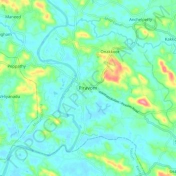
Nom : Carte topographique Piravom, altitude, relief.
Lieu : Piravom, Muvattupuzha, Ernakulam district, Kerala, 686664, India (9.83337 76.45227 9.91337 76.53227)
Altitude moyenne : 23 m
Altitude minimum : -1 m
Altitude maximum : 111 m
Faire un don
Équipez-vous pour votre prochaine aventure :
En tant que Partenaire Amazon, ce site perçoit une commission sur les achats éligibles sans surcoût pour vous.