
Faire un don
Équipez-vous pour votre prochaine aventure :
En tant que Partenaire Amazon, ce site perçoit une commission sur les achats éligibles sans surcoût pour vous.
Carte topographique Ramganga Dam
Cliquez sur la carte pour afficher l’altitude.
Faire un don
Équipez-vous pour votre prochaine aventure :
En tant que Partenaire Amazon, ce site perçoit une commission sur les achats éligibles sans surcoût pour vous.
Ramganga Dam
The dam is a 128 m (420 ft) tall and 630 m (2,067 ft) long earth and rock-fill embankment dam with 10,000,000 m3 (13,079,506 cu yd) of fill. The dam's spillway is controlled by five gates and has a maximum discharge of 8,467 m3/s (299,009 cu ft/s). To support the reservoir's elevation, there is a 72 m (236 ft) tall saddle dam on the reservoir's rim 2.5 km (2 mi) to the northeast on the Chui Sot River. The reservoir created by both dams has a 244,700,000 m3 (198,382 acre⋅ft) capacity of which 219,000,000 m3 (177,546 acre⋅ft) is active (or "useful") capacity. The reservoir has a surface of 78.31 km2 (30 sq mi) and a catchment area of 3,134 km2 (1,210 sq mi). The power station at the toe of the dam contains three 66 MW Francis turbine-generators and is afforded 84.4 m (277 ft) of design hydraulic head. Below the dam is a system of over 6,300 km (3,915 mi) of canals supported by three barrages and 82 km (51 mi) of main feeder canal.
Faire un don
Équipez-vous pour votre prochaine aventure :
En tant que Partenaire Amazon, ce site perçoit une commission sur les achats éligibles sans surcoût pour vous.
À propos de cette carte
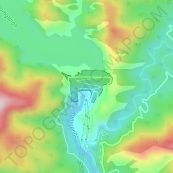
Nom : Carte topographique Ramganga Dam, altitude, relief.
Lieu : Ramganga Dam, Kotdwara, Pauri Garhwal, Uttarakhand, India (29.51557 78.75378 29.52048 78.76286)
Altitude moyenne : 389 m
Altitude minimum : 257 m
Altitude maximum : 617 m
Faire un don
Équipez-vous pour votre prochaine aventure :
En tant que Partenaire Amazon, ce site perçoit une commission sur les achats éligibles sans surcoût pour vous.
Autres cartes topographiques
Cliquez sur une carte pour visualiser sa topographie, son altitude et son relief.