
Faire un don
Équipez-vous pour votre prochaine aventure :
En tant que Partenaire Amazon, ce site perçoit une commission sur les achats éligibles sans surcoût pour vous.
Carte topographique Bandorf
Cliquez sur la carte pour afficher l’altitude.
Faire un don
Équipez-vous pour votre prochaine aventure :
En tant que Partenaire Amazon, ce site perçoit une commission sur les achats éligibles sans surcoût pour vous.
À propos de cette carte
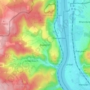
Nom : Carte topographique Bandorf, altitude, relief.
Altitude moyenne : 131 m
Altitude minimum : 51 m
Altitude maximum : 248 m
Faire un don
Équipez-vous pour votre prochaine aventure :
En tant que Partenaire Amazon, ce site perçoit une commission sur les achats éligibles sans surcoût pour vous.
Autres cartes topographiques
Cliquez sur une carte pour visualiser sa topographie, son altitude et son relief.
Kripp
Deutschland > Rheinland-Pfalz > Landkreis Ahrweiler > Remagen
Kripp teilt sich in das Ober- und Unterdorf, unterschieden nach der Höhenlage am Rheinufer. Sein Wahrzeichen ist der Kripper Wasserturm (erbaut 1904), der sich weithin sichtbar über die Gärten erhebt und unter Denkmalschutz gestellt wurde.
Altitude moyenne : 75 m
Rodderberg
Deutschland > Rheinland-Pfalz > Landkreis Ahrweiler > Remagen > Rolandswerth
Der Rodderberg liegt direkt oberhalb vom nördlichen Ausgang des Mittelrheintals. Zusammen mit dem fast direkt gegenüberliegenden Drachenfels verengt er das Rheintal. Diese Engstelle bildet die Südgrenze der Kölner Bucht, während sich südlich dieser Engstelle die kleine Talverbreiterung von Oberwinter…
Altitude moyenne : 106 m
Dungkopfsee
Deutschland > Rheinland-Pfalz > Landkreis Ahrweiler > Remagen > Unkelbach
Altitude moyenne : 177 m