
Faire un don
Équipez-vous pour votre prochaine aventure :
En tant que Partenaire Amazon, ce site perçoit une commission sur les achats éligibles sans surcoût pour vous.
Carte topographique Topton
Cliquez sur la carte pour afficher l’altitude.
Faire un don
Équipez-vous pour votre prochaine aventure :
En tant que Partenaire Amazon, ce site perçoit une commission sur les achats éligibles sans surcoût pour vous.
À propos de cette carte
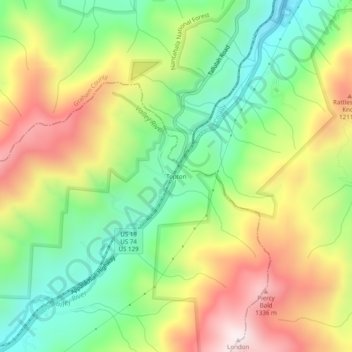
Nom : Carte topographique Topton, altitude, relief.
Lieu : Topton, Cherokee County, North Carolina, United States (35.22703 -83.72323 35.26703 -83.68323)
Altitude moyenne : 980 m
Altitude minimum : 672 m
Altitude maximum : 1 388 m
Faire un don
Équipez-vous pour votre prochaine aventure :
En tant que Partenaire Amazon, ce site perçoit une commission sur les achats éligibles sans surcoût pour vous.
Autres cartes topographiques
Cliquez sur une carte pour visualiser sa topographie, son altitude et son relief.
Murphy
United States > North Carolina > Cherokee County
Murphy is located in southwestern North Carolina, approximately halfway between Atlanta, Georgia and Knoxville, Tennessee. The topography consists of gentle rolling hills and mountains with tall peaks, including ranges from 1800 ft to more than 5000 ft elevation. The location in the Blue Ridge Mountains has…
Altitude moyenne : 514 m
Andrews
United States > North Carolina > Cherokee County
Until the early 1960s, all Andrews schools were located next to each other on the property of the current elementary school. A 1935 topographic map of Andrews shows each school building, marked with a flag, located adjacent to each other on Walnut Street (now Jean Christy Avenue) and Fourth Street. The current…
Altitude moyenne : 593 m
Murphy
United States > North Carolina > Cherokee County
Murphy has a humid subtropical climate, (Cfa) according to the Köppen classification, with hot, humid summers and cool to mild winters, with low temperatures significantly cooler than other parts of the Southeast, due in part to the elevation. Like the rest of the southeastern U.S., Murphy receives abundant…
Altitude moyenne : 514 m
Murphy
United States > North Carolina > Cherokee County
Murphy is located in southwestern North Carolina, approximately halfway between Atlanta, Georgia and Knoxville, Tennessee. The topography consists of gentle rolling hills and mountains with tall peaks, including ranges from 1800 ft to more than 5000 ft elevation. The location in the Blue Ridge Mountains has…
Altitude moyenne : 514 m
Faire un don
Équipez-vous pour votre prochaine aventure :
En tant que Partenaire Amazon, ce site perçoit une commission sur les achats éligibles sans surcoût pour vous.
Andrews
United States > North Carolina > Cherokee County
Until the early 1960s, all Andrews schools were located next to each other on the property of the current elementary school. A 1935 topographic map of Andrews shows each school building, marked with a flag, located adjacent to each other on Walnut Street (now Jean Christy Avenue) and Fourth Street. The current…
Altitude moyenne : 593 m