
Faire un don
Équipez-vous pour votre prochaine aventure :
En tant que Partenaire Amazon, ce site perçoit une commission sur les achats éligibles sans surcoût pour vous.
Carte topographique Texas City
Cliquez sur la carte pour afficher l’altitude.
Faire un don
Équipez-vous pour votre prochaine aventure :
En tant que Partenaire Amazon, ce site perçoit une commission sur les achats éligibles sans surcoût pour vous.
Texas City
Officially, the elevation of Texas City is 10 feet above sea level, though some areas are even lower. It was naturally vulnerable to flooding by hurricane storm surges and heavy rainstorms.
Faire un don
Équipez-vous pour votre prochaine aventure :
En tant que Partenaire Amazon, ce site perçoit une commission sur les achats éligibles sans surcoût pour vous.
À propos de cette carte
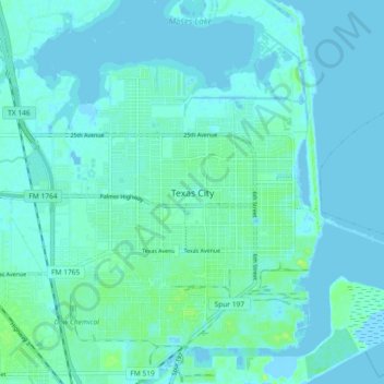
Nom : Carte topographique Texas City, altitude, relief.
Lieu : Texas City, Galveston County, Texas, 77590, United States (29.35601 -94.95755 29.43601 -94.87755)
Altitude moyenne : 3 m
Altitude minimum : -4 m
Altitude maximum : 14 m
Faire un don
Équipez-vous pour votre prochaine aventure :
En tant que Partenaire Amazon, ce site perçoit une commission sur les achats éligibles sans surcoût pour vous.